 Filter: Categories of Wisconsin Historical Images
Filter: Subject of Landscape
Filter: County of Dane
Filter: Categories of Wisconsin Historical Images
Filter: Subject of Landscape
Filter: County of Dane

| Date: | 07 30 1960 |
|---|---|
| Description: | View towards horizon of long shadows stretching across a large field. Small plants grows in the foreground. |

| Date: | 05 28 1961 |
|---|---|
| Description: | Landscape view of a rolling countryside. A farm is visible in the distance. |

| Date: | 05 30 1964 |
|---|---|
| Description: | Landscape view from field of a rolling countryside. A small cheese factory resides on a slope, with a tree, a windmill, two cars and a tractor near an outb... |
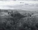
| Date: | 06 1967 |
|---|---|
| Description: | Elevated landscape view of farmland rolling to the horizon. Patches of trees grow throughout the pastures. |

| Date: | 01 12 1952 |
|---|---|
| Description: | A scene in Vilas Park showing frost covered trees and a lone vehicle. |

| Date: | |
|---|---|
| Description: | Old Abe, the eagle mascot of the 8th Regiment of the Wisconsin Volunteer Infantry, perched on a log with the background of a rural Wisconsin valley. Captio... |
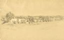
| Date: | 1852 |
|---|---|
| Description: | Pencil drawing of trees around the shore of a lake from across a field. |
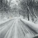
| Date: | 1960 |
|---|---|
| Description: | A winter scene down a road in the snow-covered arboretum. |

| Date: | |
|---|---|
| Description: | Photographic postcard of the view to the west from the top of Blue Mounds, in Blue Mounds State Park. Handwritten is "Platteville Mounds, 45 miles" with an... |

| Date: | |
|---|---|
| Description: | Photographic postcard of the northwest view of Blue Mounds. Text below in a white box reads "N.W. View of Blue Mounds, Wis. Elevation 1760 ft." |

| Date: | |
|---|---|
| Description: | Photographic postcard of the view towards Madison from the top of Blue Mounds. Handwritten on the card is "State Capitol, 25 miles" with an arrow. Text bel... |
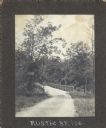
| Date: | 1905 |
|---|---|
| Description: | The rustic bridge on Lake Mendota Drive, over a ravine in Shorewood Hills. The sign on the left reads: "$5 FINE, For riding or driving over this bridge fas... |
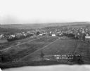
| Date: | 1916 |
|---|---|
| Description: | Bird's-eye view of town. Fields, with farms and fences, surround the town made up of numerous dwellings and a church. |
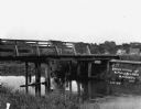
| Date: | 1909 |
|---|---|
| Description: | View from shoreline of wooden bridge. There are homes and barns in the distance. |
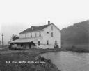
| Date: | 1925 |
|---|---|
| Description: | View along shoreline of a mill on a river. There is a man loading bags onto a cart at the front. There is a wooded hill on the right. |
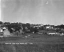
| Date: | 1930 |
|---|---|
| Description: | Bird's-eye view town. There are barns, homes, a church's steeple and a lumberyard. |

| Date: | |
|---|---|
| Description: | View of the village from the railroad tracks. There is a church among the cluster of homes. |

| Date: | |
|---|---|
| Description: | View looking down hill of several buildings. More hills are in the far background. Caption reads: "Blue Mounds at a Distance, Altitude 1760 FT." |

| Date: | 1925 |
|---|---|
| Description: | A view looking up a winding road with rows of utility lines on both sides. The road is partially fenced. |

| Date: | |
|---|---|
| Description: | View from hill over church and cemetery towards fields and town in a valley. |
If you didn't find the material you searched for, our Library Reference Staff can help.
Call our reference desk at 608-264-6535 or email us at: