Filter: Categories of Wisconsin Historical Images
Filter: Subject of Landscape
Filter: Creator Name of Unknown
Filter: Categories of Wisconsin Historical Images
Filter: Subject of Landscape
Filter: Creator Name of Unknown

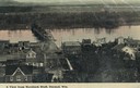
| Date: | 1902 |
|---|---|
| Description: | River with distant hills behind a town. An island is in the foreground. |
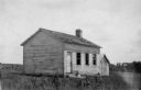
| Date: | |
|---|---|
| Description: | View of the one-room schoolhouse, located 2 1/2 miles south of Dickeyville. |
| Date: | 1900 |
|---|---|
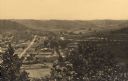
| Description: | Elevated view of Durand. A street in the foreground leads to a bridge that crosses the river. Caption reads: "A View from Morsbach Bluff, Durand, Wis." |
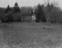
| Date: | |
|---|---|
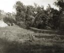
| Description: | Rock Studio across a field, surrounded by trees. |
| Date: | |
|---|---|
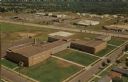
| Description: | Aerial view of the high school, 2100 Fenwick Avenue, and the surrounding roads. |
| Date: | |
|---|---|
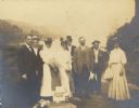
| Description: | A boat trip group, possibly William Arthur Jones and others. |

| Date: | 1905 |
|---|---|
| Description: | View across field and fence downhill towards the town of Fish Creek and the bay. Caption reads: "Greetings from Fish Creek, Wis." |

| Date: | |
|---|---|
| Description: | Caption reads: "Air View — Fountain City, Wis." Aerial view of town and surrounding landscape that includes trees, rolling hills, and a river. |

| Date: | 1925 |
|---|---|
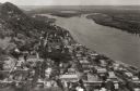
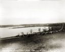
| Description: | Bird's-eye view of Fountain City looking south, with high bluff on the left, and the Mississippi River on the right. Fountain City, about 4 blocks wide, ne... |
| Date: | 1877 |
|---|---|
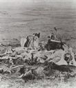
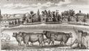
| Description: | View of cattle, sheep, and pigs in a pasture on a farm. Two houses are in the distance, and a horse-drawn carriage is moving along the road on the left. Ca... |
| Date: | 1927 |
|---|---|
| Description: | View down hill towards the Fox River from the Eleazer Williams home. A group of people are automobiles are near a road near the shoreline. |

| Date: | 1832 |
|---|---|
| Description: | Route of Military Road from Fort Crawford to Fort Howard. Map shows beginning of route at Fort Crawford. |
| Date: | |
|---|---|
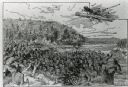
| Description: | An illustration titled "The Battle of the Brule" based on an 1840's battle between the Ojibwe and Dakota Sioux over territory in the Ashland, Wisconsin are... |

| Date: | 03 1963 |
|---|---|
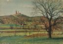
| Description: | Panoramic landscape view of the Fey Farm near Dexterville, Wood County. The view shows the farmstead and much of the surrounding acreage and woodlands. T... |
If you didn't find the material you searched for, our Library Reference Staff can help.
Call our reference desk at 608-264-6535 or email us at: