 Filter: Categories of Wisconsin Historical Images
Filter: Subject of Landscape
Filter: Creator Name of Unknown
Filter: Type of Map or Atlas
Filter: Categories of Wisconsin Historical Images
Filter: Subject of Landscape
Filter: Creator Name of Unknown
Filter: Type of Map or Atlas

| Date: | 1832 |
|---|---|
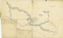
| Description: | Route of Military Road from Fort Crawford to Fort Howard. Map shows beginning of route at Fort Crawford. |
| Date: | 1862 |
|---|---|
| Description: | A hand-drawn map of the Yazoo River and vicinity. |

| Date: | 1899 |
|---|---|
| Description: | Overhead map of the Stanley McCormick's Riven Rock estate in El Montecito, Santa Barbara, California. The map shows the placement of dwellings and fields, ... |

| Date: | 1881 |
|---|---|
| Description: | Bird's-eye view of Milwaukee from the south lakeshore. |

| Date: | 1846 |
|---|---|
| Description: | This map is paint and ink on board with relief shown pictorially. The map was planned by Alfred Ames, drawn by one daughter and painted by another daughter... |

| Date: | |
|---|---|
| Description: | A map captioned: "Diagram of the Region Destitute of Drift and Boulders in Wisconsin, Iowa and Minnesota." |
If you didn't find the material you searched for, our Library Reference Staff can help.
Call our reference desk at 608-264-6535 or email us at: