 Filter: Categories of Wisconsin Historical Images
Filter: Subject of Landscape
Filter: Type of Drawing
Filter: Subject of dwellings
Filter: Categories of Wisconsin Historical Images
Filter: Subject of Landscape
Filter: Type of Drawing
Filter: Subject of dwellings

| Date: | 1852 |
|---|---|
| Description: | Pencil drawing of Madison landscape as seen from University Hill. The main street in the center is State Street, and the building with Greek columns in the... |
| Date: | 1852 |
|---|---|
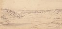
| Description: | Pencil drawing of Black Earth Valley. Gentle lightly tree-covered hills frame the center grassy valley. Two farmhouses are sitting at the base of hills on ... |
| Date: | 1877 |
|---|---|
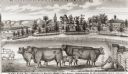
| Description: | View of cattle, sheep, and pigs in a pasture on a farm. Two houses are in the distance, and a horse-drawn carriage is moving along the road on the left. Ca... |
| Date: | 05 1849 |
|---|---|
| Description: | A farm in Missouri with one wagon visible. Sketched by Wilkins on his 151-day journey from Missouri to California on the Overland Trail (also known as the ... |
| Date: | 05 1849 |
|---|---|
| Description: | The bottom lands and a farm in Missouri; Sketched by Wilkins on his 151-day journey from Missouri to California on the Overland Trail (also known as the Or... |
| Date: | 07 25 1849 |
|---|---|
| Description: | Fort Bridger in Wyoming, with wagon parts and teepees, where Wilkins camped for a night; sketched by Wilkins on his 151-day journey from Missouri to Califo... |
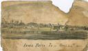
| Date: | 1866 |
|---|---|
| Description: | An image from a sketchbook of the town of Iowa Falls. There is a fence in the foreground and buildings in the background. |

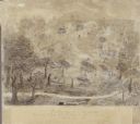
| Date: | |
|---|---|
| Description: | A preliminary sketch of a landscape with partially drawn cannons in the foreground and tents in the background. |
| Date: | |
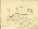
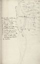
|---|---|
| Description: | Drawn map of Blackstock's Plantation battlefield from the Sumter Papers. |
| Date: | |
|---|---|
| Description: | Drawn map of Blackstock's Plantation battlefield from the Thomas Sumter Papers. |
| Date: | 08 1852 |
|---|---|
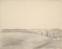
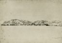
| Description: | Pencil drawing of Rattlesnake Bluff and the town of Arena from a distance across a plain. A row of buildings runs along the foot of the gently rolling hill... |
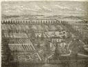
| Date: | 1878 |
|---|---|
| Description: | Engraved view of a house surrounded by gardens, an evergreen shelter belt and ornamental hedges. |
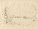
| Date: | 1852 |
|---|---|
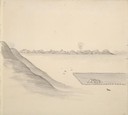
| Description: | Rural landscape with farm buildings seen from across a field and framed by trees. |
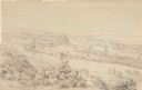
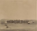
| Date: | 1852 |
|---|---|
| Description: | Landscape view of Fort Snelling, Minnesota Territory from a nearby hill showing the Fort, the Mississippi river, the countryside, farm buildings and tipis.... |
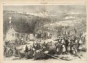
| Date: | 12 17 1862 |
|---|---|
| Description: | Illustration depicting a battle. In the foreground injured soldiers are gathered on and around the porch and yard of a house. In the background are columns... |

| Date: | 1897 |
|---|---|
| Description: | Topographical map of Stanley McCormick's Riven Rock estate in El Montecito, Santa Barbara County, California. The map is identified as a map of a survey co... |
| Date: | 1845 |
|---|---|
| Description: | Drawing of Shullsburg. Text at bottom reads: "Smelting lead ore in log furnaces. Scene in Gratiots Grove at Shullsburg, Wis. in 1845-6. Drawn from life. By... |
If you didn't find the material you searched for, our Library Reference Staff can help.
Call our reference desk at 608-264-6535 or email us at: