Filter: Categories of Wisconsin Historical Images
Filter: Subject of Landforms
Filter: Year of 1900-1999
Filter: Year of 1910-1919
Filter: Categories of Wisconsin Historical Images
Filter: Subject of Landforms
Filter: Year of 1900-1999
Filter: Year of 1910-1919
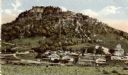
| Date: | 1913 |
|---|---|
| Description: | Elevated view of Taliesin. Taliesin is located in the vicinity of Spring Green. |

| Date: | 1910 |
|---|---|
| Description: | Bird's-eye view looking east, with Washburn Harbor at center and Chequamegon Bay in Lake Superior covering most of the upper image. Streets with buildings... |
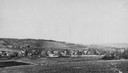
| Date: | 1910 |
|---|---|
| Description: | View from hill looking down at Cross Plains. |

| Date: | 1919 |
|---|---|
| Description: | Aerial view with the Wisconsin State Capitol in the foreground, and the tip of Monona Bay and Lake Wingra to the left, with horizon stretching into the dis... |

| Date: | 1910 |
|---|---|
| Description: | Colorized view of the Maiden's Rock, as viewed from Lake City, Minnesota. This was the legendary lover's leap of Wenonah, the first-born daughter of Dakota... |

| Date: | 1910 |
|---|---|
| Description: | Wisconsin Geological and Natural History Survey, by Lawrence Martin reproduced from a model of the state prepared by W.O. Hotchkiss and F.T. Thwaites and m... |

| Date: | 1916 |
|---|---|
| Description: | Southeastern Wisconsin which lies east of Whitewater and south of Port Washington. |

| Date: | 1915 |
|---|---|
| Description: | Elevated view of Pontoon Bridge. Caption reads: "Largest Pontoon Bridge in the U.S. Scene at the Tri Cities, North and South McGergor and Prairie du Chien.... |
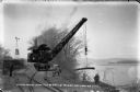
| Date: | 03 1911 |
|---|---|
| Description: | Workers use a rail car mounted crane to load pilings onto a barge. Bluffs are in the distance. |
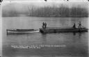
| Date: | 03 1911 |
|---|---|
| Description: | A gasoline-powered launch tows a barge loaded with log pilings on the Wisconsin River to the Prairie du Sac dam site. Workmen drive the launch and guide th... |
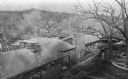
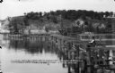
| Date: | 04 1911 |
|---|---|
| Description: | Workmen pose on a steam-powered pile driver at work at the north end of the slough on the Wisconsin River. The railroad was extended from the village to th... |
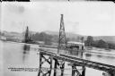
| Date: | 06 19 1911 |
|---|---|
| Description: | Looking west over the Wisconsin River at the unfinished narrow gauge railroad trestle built for construction of the dam. Two pile drivers are seen in the a... |
| Date: | 06 21 1911 |
|---|---|
| Description: | Looking east over the Wisconsin River showing the unfinished narrow gauge railroad trestle. Two steam-driven pile drivers on barges with construction worke... |
| Date: | 12 29 1912 |
|---|---|
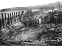
| Description: | Elevated view of the progress within the coffer dam showing concrete forms around the draft tubes and gate guides. The high trestle is seen extending to th... |
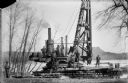
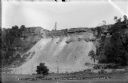
| Date: | 06 13 1913 |
|---|---|
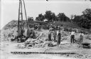
| Description: | Workmen and machinery at the quarry on Blackhawk Bluff. The gravel was used in construction of the power dam. |
| Date: | 08 19 1915 |
|---|---|
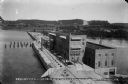
| Description: | Elevated view of the completed power house and dam, looking east at the north, or upstream, side of the structure. On the far shore, the site of the gravel... |
| Date: | 07 16 1912 |
|---|---|
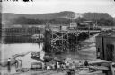
| Description: | Workers posing inside the coffer dam. The narrow gauge railroad is behind them. One of the pile drivers is in the background. A bare area on the bluff in t... |
| Date: | 06 13 1913 |
|---|---|
| Description: | A view, from the west, of the quarry on Blackhawk Bluff. Gravel from the quarry was used in concrete for the construction of the power plant and dam. |
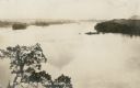
| Date: | 1910 |
|---|---|
| Description: | Elevated view of high water on the Wisconsin River from a bluff on the west bank. The photograph is undated and does not indicate if it was taken prior to ... |
If you didn't find the material you searched for, our Library Reference Staff can help.
Call our reference desk at 608-264-6535 or email us at: