 Filter: Categories of Wisconsin Historical Images
Filter: Subject of Landforms
Filter: Year of 1800-1899
Filter: Year of 1860-1869
Filter: Categories of Wisconsin Historical Images
Filter: Subject of Landforms
Filter: Year of 1800-1899
Filter: Year of 1860-1869
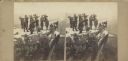
| Date: | 1864 |
|---|---|
| Description: | Albumen stereograph of the Union Army brass band posed and playing atop Lookout Point. The Tennessee River is in the background. |
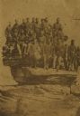
| Date: | 04 20 1864 |
|---|---|
| Description: | Company D, Twenty-first Wisconsin Volunteer Infantry. Top row (left to right): John Buboltz, Spencer Orlup, J. Henry Otto, Lyman C. Wait, Andrew Jackson, W... |

| Date: | 1867 |
|---|---|
| Description: | Birds-eye drawing of Appleton, Outagamie Co., depicting street names and street layout, houses, the Fox River, the court house, jail, school houses, Lawren... |

| Date: | 1868 |
|---|---|
| Description: | This 1868 birds-eye view depicts the buildings, streets, railroad, vegetation and topography of Columbus, Wisconsin. The high school, cemetery, railroad de... |

| Date: | 1867 |
|---|---|
| Description: | Bird's-eye map of Green Bay and Fort Howard, Brown Co., depicts street names and street layouts, houses, trees, and the East River. A reference key at the ... |

| Date: | 1860 |
|---|---|
| Description: | Bird's-eye drawing of New Glarus. |
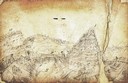
| Date: | 1862 |
|---|---|
| Description: | Sketch of Boone's Knob and the Kentucky River, where Company A of the 22nd Wisconsin Infantry camped, November-December, 1862. The sketch was drawn by Priv... |
| Date: | 04 1860 |
|---|---|
| Description: | Accompanying this sketch is Hölzlhuber's description of his last foray from Milwaukee before leaving America. "Before my return to Europe, D. Brandis, the ... |

| Date: | 1864 |
|---|---|
| Description: | Fort Crawford was decommissioned in 1856, having outlived its usefulness as a frontier post. During the Civil War, however, it functioned as a military ho... |

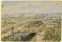
| Date: | 1868 |
|---|---|
| Description: | Elevated view up Wisconsin Avenue showing City Hall on the corner at Mifflin Street on the left, with the Post Office to the right. Further down is the Pre... |

| Date: | 1868 |
|---|---|
| Description: | Showing the counties, towns and railroads. Partly colored. Scale: 1 inch = 20 miles. |

| Date: | 1862 |
|---|---|
| Description: | Lithography of C. Van Benthuysen. |

| Date: | 1869 |
|---|---|
| Description: | Increase A. Lapham in the foreground of a rock formation in Taylor's Glen, with A. Holly sitting on a rock in the background. |

| Date: | 1864 |
|---|---|
| Description: | View across the Tennessee River toward the city and Cameron Hill, showing the military bridge and some Union Army installations put up following the occupa... |
| Date: | 1863 |
|---|---|
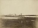
| Description: | View from shoreline of the side-wheel steamship "Thomas Powell," probably in southern waters. Industrial buildings are in the background. |

| Date: | 1866 |
|---|---|
| Description: | Exterior of Fort Sumter. A cannon has fallen on the steep shoreline and waves are hitting the rocks. Plate 58 |
| Date: | 1864 |
|---|---|
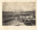
| Description: | Confederate defenses surrounding the city. A tripod style configuration of rifles with a bag and canteen hanging from it is in the foreground. Plate 43<... |
| Date: | 1864 |
|---|---|
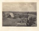
| Description: | One of the Confederate defenses surrounding the city. This view is of the inside of the earthworks which includes two cannons. A Union soldier sits as a lo... |

| Date: | 1864 |
|---|---|
| Description: | View looking out from one of the Confederate defenses around the outside of the city. Wooden palisades surround the earthworks. Houses and other buildings ... |

| Date: | 1866 |
|---|---|
| Description: | The south bank of the Chattahoochie River with a bridge spanning it. In the foreground are some battlements. Plate 33 |
If you didn't find the material you searched for, our Library Reference Staff can help.
Call our reference desk at 608-264-6535 or email us at: