 Filter: Categories of Wisconsin Historical Images
Filter: Subject of Landforms
Filter: Year of 1800-1899
Filter: Categories of Wisconsin Historical Images
Filter: Subject of Landforms
Filter: Year of 1800-1899

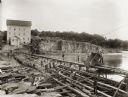
| Date: | 1895 |
|---|---|
| Description: | View of a mill, sluice and dam on Waumandee Creek. The mill was built by John Oschner in 1863. Two products produced by the mill were White Rose Flour and ... |

| Date: | 1856 |
|---|---|
| Description: | Isthmus of Madison, including Lake Mendota, or Great Lake, and Lake Menona [sic]. |

| Date: | 1804 |
|---|---|
| Description: | A map of Lewis and Clark's Track across the western portion of North America from the Mississippi River to the Pacific Ocean by order of the Executive of t... |

| Date: | 07 01 1836 |
|---|---|
| Description: | Original plat map of the town of Madison on the four lakes. |

| Date: | 1885 |
|---|---|
| Description: | Stereograph view of Menomonie. A group of people are sitting on a hill in the foreground overlooking the town. |
| Date: | 1845 |
|---|---|
| Description: | View of the gorge at St. Croix with a boat and multiple figures visible in the background. |

| Date: | 1864 |
|---|---|
| Description: | Fort Crawford was decommissioned in 1856, having outlived its usefulness as a frontier post. During the Civil War, however, it functioned as a military ho... |

| Date: | 1829 |
|---|---|
| Description: | Cincinnati, Ohio, Ebr. Martin, engraver. |

| Date: | 1848 |
|---|---|
| Description: | Immigrant map. |

| Date: | 1868 |
|---|---|
| Description: | Elevated view up Wisconsin Avenue showing City Hall on the corner at Mifflin Street on the left, with the Post Office to the right. Further down is the Pre... |
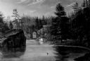
| Date: | 1895 |
|---|---|
| Description: | Munger's Mill and dam, with men standing on and around the dam. |
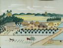
| Date: | 1875 |
|---|---|
| Description: | Seifert's watercolor is fairly large, measuring 27" wide by 21" high, and provides a detailed depiction of a nineteenth century Wisconsin farm. The small s... |

| Date: | 1882 |
|---|---|
| Description: | This basic reference map of the state shows natural features, railroads, county seats, and political boundaries against the G.L.O. township and range grid.... |

| Date: | 1830 |
|---|---|
| Description: | A color map of the Michigan and Wisconsin territories with an inset showing the Ste. Marie River. |

| Date: | 1868 |
|---|---|
| Description: | Showing the counties, towns and railroads. Partly colored. Scale: 1 inch = 20 miles. |

| Date: | 1862 |
|---|---|
| Description: | Lithography of C. Van Benthuysen. |

| Date: | 1839 |
|---|---|
| Description: | Shows locations of cities, towns, villages, post hamlets, canals, rail and stage roads. Includes table of steamboat routes and distances; vignette of "Maid... |

| Date: | 1869 |
|---|---|
| Description: | Increase A. Lapham in the foreground of a rock formation in Taylor's Glen, with A. Holly sitting on a rock in the background. |
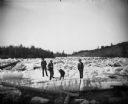
| Date: | 1876 |
|---|---|
| Description: | Three men and a dog are standing on thick chunks of ice looking over logs on an icy river. |
| Date: | 05 19 1895 |
|---|---|
| Description: | A view from the bluff of group of men on the dredge bank of Buffalo Lake. |
If you didn't find the material you searched for, our Library Reference Staff can help.
Call our reference desk at 608-264-6535 or email us at: