 Filter: Categories of Wisconsin Historical Images
Filter: Subject of Landforms
Filter: Year of 1800-1899
Filter: Categories of Wisconsin Historical Images
Filter: Subject of Landforms
Filter: Year of 1800-1899
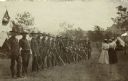
| Date: | 1887 |
|---|---|
| Description: | Members of the Wisconsin National Guard Light Horse Squadron, Troop A standing in a row. Three women and one man, visitors to Camp Douglas, stand facing th... |

| Date: | 1896 |
|---|---|
| Description: | Shows pipes of various sizes, hydrants with hydrant pressure, valves, wells, projected lines, and suction pipes. Differs from earlier versions by inclusion... |

| Date: | 09 04 1885 |
|---|---|
| Description: | Exterior and interior bill of fare from The Chequamegon, with views on the back of rock formations, waterfalls, a spot illustration of a train going over a... |
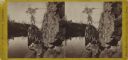
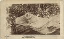
| Date: | 1870 |
|---|---|
| Description: | Stereograph of the dalles of the St. Croix river, on the Wisconsin-Minnesota border. Along the shoreline on the right, a woman in a long dress is posing on... |

| Date: | 1861 |
|---|---|
| Description: | The township of Primrose, which is a detail from the plat map of Dane County. |

| Date: | 1861 |
|---|---|
| Description: | The township of Montrose, which is a detail from a Dane County plat map. |

| Date: | 1857 |
|---|---|
| Description: | This map shows section corners, quarter section corners, foundry, steam saw mill, steam grist mill, planning mill, court house, baptist church, congregatio... |

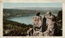
| Date: | 1895 |
|---|---|
| Description: | Elevated view from bluffs, looking north-east toward Lake City, Minnesota and Lake Pepin of the Mississippi River. |
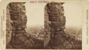
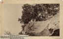
| Date: | 1890 |
|---|---|
| Description: | Stereograph view from the bluffs looking down over a town. A man is standing on the edge of the side of the formation, about halfway up, above treeline, an... |
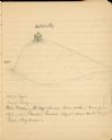
| Date: | 1897 |
|---|---|
| Description: | A pencil sketch of Butte des Morts, also called Hill of the Dead. There is a small building at the top of the hill. |

| Date: | 09 01 1856 |
|---|---|
| Description: | This map is pen-and-ink and shows farm lots, other lots of land sectioned by acres, bluffs, and a coulee. Also included are notations in pencil and blue in... |

| Date: | 1899 |
|---|---|
| Description: | A plat map showing Lake Monona, the isthmus in Madison, and the towns of Burke and Blooming Grove. |
| Date: | 1888 |
|---|---|
| Description: | View looking up at three men and a child on top of a cliff on which are petroglyphs. Caption on photograph reads: "Pictograph Rock. Rock bearing aboriginal... |
| Date: | 1888 |
|---|---|
| Description: | View looking up at three men and a child on top of a cliff on which are petroglyphs. Pictograph Rock bearing aboriginal carvings, located on the south side... |

| Date: | 1871 |
|---|---|
| Description: | A map of California showing railroad lines and reservations. |
| Date: | 1898 |
|---|---|
| Description: | Colorized postcard of an elevated view of the Devil's Doorway rock formation at Devil's Lake State Park. Devil's Lake is below in the background. Caption r... |

| Date: | 1853 |
|---|---|
| Description: | A map of Wellfleet Harbor on Cape Cod Bay. |

| Date: | 1890 |
|---|---|
| Description: | Plat map of Madison, T7N R9E, including portions of the towns of Blooming Grove and Burke. Includes inset maps of South Madison, Quarrytown, Marril Park, a... |

| Date: | 1885 |
|---|---|
| Description: | Elevated view over trees towards the Mississippi River. 1885-90. Across the field in the foreground are people with an American flag standing along the sho... |
If you didn't find the material you searched for, our Library Reference Staff can help.
Call our reference desk at 608-264-6535 or email us at: