 Filter: Categories of Wisconsin Historical Images
Filter: Subject of Landforms
Filter: Subject of water
Filter: Categories of Wisconsin Historical Images
Filter: Subject of Landforms
Filter: Subject of water

| Date: | 1902 |
|---|---|
| Description: | River with distant hills behind a town. An island is in the foreground. |
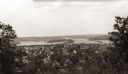
| Date: | |
|---|---|
| Description: | Elevated view of the residential section of Eau Claire from Mount Tom. |

| Date: | 1870 |
|---|---|
| Description: | Elevated view of the town, looking northwest. The Chippewa River is in the foreground, with a lot of buildings, an intersection, and distant hills. One bui... |

| Date: | 1928 |
|---|---|
| Description: | Aerial view of Madison looking southeast over the isthmus, showing the Four Lakes Country. Visible at the bottom is the Lake Mendota shoreline. At center, ... |

| Date: | 1956 |
|---|---|
| Description: | Aerial view looking northeast from a point over the east end of Middleton, showing the west end of Lake Mendota (right mid-ground). Fox Bluff juts into the... |

| Date: | 1955 |
|---|---|
| Description: | An air view of Madison's downtown area with the Wisconsin State Capitol and new State Office Buildings. |

| Date: | 1950 |
|---|---|
| Description: | Aerial view of the Madison isthmus looking north. Caption reads: "Madison Wisconsin — Between Lake Mendota and Lake Monona". |

| Date: | 1924 |
|---|---|
| Description: | Aerial view of Madison's Willow Beach towards the University of Wisconsin-Madison campus, downtown Madison, and Lake Monona. |
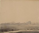
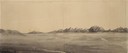
| Date: | 07 10 1849 |
|---|---|
| Description: | The clay hills that were formed by the Sweetwater River in Wyoming; sketched by Wilkins on his 151-day journey from Missouri to California on the Overland ... |
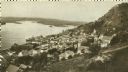
| Date: | 1920 |
|---|---|
| Description: | Elevated view of Fountain City with the Mississippi River in the background. |

| Date: | 1919 |
|---|---|
| Description: | Aerial view with the Wisconsin State Capitol in the foreground, and the tip of Monona Bay and Lake Wingra to the left, with horizon stretching into the dis... |

| Date: | 1930 |
|---|---|
| Description: | Aerial view of isthmus looking east toward Lake Mendota and the Wisconsin State Capitol, with Lake Monona and the horizon in the background. |

| Date: | 07 06 1937 |
|---|---|
| Description: | Aerial view of the west central part of isthmus and the University of Wisconsin campus. |
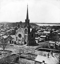
| Date: | |
|---|---|
| Description: | Elevated view of the First Congregational Church and chapel at the corner of North Fairchild Street and West Washington Avenue. The Gates of Heaven Synagog... |
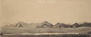
| Date: | 07 10 1849 |
|---|---|
| Description: | Sweetwater River and the Red Buttes in Wyoming; sketched by Wilkins on his 151-day journey from Missouri to California on the Overland Trail (also known as... |
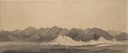
| Date: | 07 17 1849 |
|---|---|
| Description: | Pacific Springs, Wyoming; sketched by Wilkins on his 151-day journey from Missouri to California on the Overland Trail (also known as the Oregon Trail). Wi... |
| Date: | 08 03 1849 |
|---|---|
| Description: | Bear or Soda Springs along Bear River in Idaho; sketched by Wilkins on his 151-day journey from Missouri to California on the Overland Trail (also known as... |
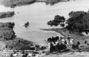
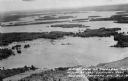
| Date: | 1955 |
|---|---|
| Description: | Aerial view of Treeland Pines resort on Lake Chippewa. Caption reads: "Air View of Bob Cammack's Treeland Pines Resort; Lake Chippewa, Hayward, Wis." |
| Date: | 1955 |
|---|---|
| Description: | Aerial view of Treeland Pines Resort on Lake Chippewa. Caption reads: "Aerial View of Treeland Pines Resort on Lake Chippewa (The Flowage), Hayward, Wis." |
If you didn't find the material you searched for, our Library Reference Staff can help.
Call our reference desk at 608-264-6535 or email us at:
