Filter: Categories of Wisconsin Historical Images
Filter: Subject of Landforms
Filter: Subject of persons
Filter: Categories of Wisconsin Historical Images
Filter: Subject of Landforms
Filter: Subject of persons

| Date: | 1673 |
|---|---|
| Description: | P. Marquette en Joliet, gedan in't jaar 1673. |

| Date: | 1868 |
|---|---|
| Description: | Elevated view up Wisconsin Avenue showing City Hall on the corner at Mifflin Street on the left, with the Post Office to the right. Further down is the Pre... |
| Date: | 1895 |
|---|---|
| Description: | Munger's Mill and dam, with men standing on and around the dam. |
| Date: | 1920 |
|---|---|
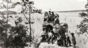
| Description: | A group of Indians, probably Ho-Chunk, in traditional costume, posing on and around Demon's Anvil. |
| Date: | 1875 |
|---|---|
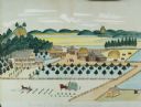
| Description: | Seifert's watercolor is fairly large, measuring 27" wide by 21" high, and provides a detailed depiction of a nineteenth century Wisconsin farm. The small s... |
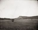
| Date: | 1900 |
|---|---|
| Description: | Distant view of Black Hawk Lookout near the Wisconsin River. There is an open field with a single tree and a fence in the foreground. |

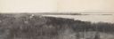
| Date: | 10 1905 |
|---|---|
| Description: | Elevated view from Reservoir Bluff to the east of the town. The bluffs of Iowa can be seen in the distance. |
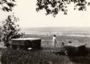
| Date: | 1925 |
|---|---|
| Description: | Brisbois grave, tomb of Michael Brisbois. A woman is standing behind the graves, looking out to Prairie du Chien and the Mississippi River. |

| Date: | 1950 |
|---|---|
| Description: | Elevated view of the bridge across the Mississippi River between Prairie du Chien, Wisconsin and Marquette, Iowa. Caption reads: "Suspension Bridge Between... |
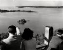
| Date: | 1945 |
|---|---|
| Description: | People on observation tower looking at Sturgeon Bay. |

| Date: | 1869 |
|---|---|
| Description: | Increase A. Lapham in the foreground of a rock formation in Taylor's Glen, with A. Holly sitting on a rock in the background. |
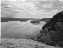
| Date: | 08 03 1946 |
|---|---|
| Description: | View of the Wisconsin River from Cactus Bluff. |
| Date: | |
|---|---|
| Description: | The Battle of Chattanooga from the Milwaukee-based American Panoramic Company's cyclorama "The Storming of Missionary Ridge." |
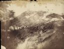
| Date: | |
|---|---|
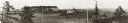
| Description: | Panoramic photograph from top of Bascom Hall facing northwest, showing Picnic Point on the University of Wisconsin campus. Washburn Observatory visible to ... |
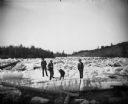
| Date: | 1876 |
|---|---|
| Description: | Three men and a dog are standing on thick chunks of ice looking over logs on an icy river. |
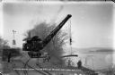
| Date: | 03 1911 |
|---|---|
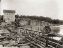
| Description: | Workers use a rail car mounted crane to load pilings onto a barge. Bluffs are in the distance. |
| Date: | 03 1911 |
|---|---|
| Description: | A gasoline-powered launch tows a barge loaded with log pilings on the Wisconsin River to the Prairie du Sac dam site. Workmen drive the launch and guide th... |
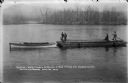
| Date: | 04 1911 |
|---|---|
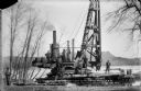
| Description: | Workmen pose on a steam-powered pile driver at work at the north end of the slough on the Wisconsin River. The railroad was extended from the village to th... |
If you didn't find the material you searched for, our Library Reference Staff can help.
Call our reference desk at 608-264-6535 or email us at: