 Filter: Categories of Wisconsin Historical Images
Filter: Subject of Landforms
Filter: Subject of persons
Filter: Subject of islands
Filter: Categories of Wisconsin Historical Images
Filter: Subject of Landforms
Filter: Subject of persons
Filter: Subject of islands
| Date: | |
|---|---|
| Description: | Devils Island on Lake Superior, outermost of the Apostle Islands group. There appears to be the edge of a boat in the foreground. |

| Date: | |
|---|---|
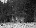
| Description: | Two men posing on bluffs overlooking the Mississippi River at Fountain City. Fountain Brewery is visible at bottom right. |

| Date: | 1902 |
|---|---|
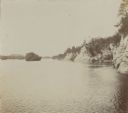
| Description: | River with distant hills behind a town. An island is in the foreground. |
| Date: | |
|---|---|
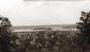
| Description: | Elevated view of the residential section of Eau Claire from Mount Tom. |
| Date: | 1920 |
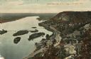
|---|---|
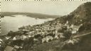
| Description: | Elevated view of Fountain City with the Mississippi River in the background. |
| Date: | 08 03 1946 |
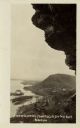
|---|---|
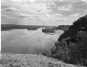
| Description: | View of the Wisconsin River from Cactus Bluff. |
| Date: | |
|---|---|
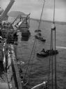
| Description: | Wounded soldiers are being loaded onto a hospital ship in Iwo Jima. |
| Date: | 08 23 1964 |
|---|---|
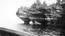
| Description: | A large rock outcropping covered with trees and plants on a rocky beach of Lake Michigan. |
| Date: | |
|---|---|
| Description: | View of the Wisconsin River and the surrounding geological landforms. |
| Date: | |
|---|---|
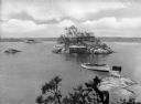
| Description: | Elevated view from Hubinger's Island featuring other islands, homes, and a boat. |

| Date: | |
|---|---|
| Description: | Hand-drawn map of the area at the time of Pilgrim landing, drawn by Charles Blaskowikz. Includes commemorative historical notes. |

| Date: | 1938 |
|---|---|
| Description: | View of a house on Nebraska Row on Madeline Island. In the foreground is a flag pole, bench, path, lawn and trees. On the left are docks from the lake shor... |

| Date: | 1915 |
|---|---|
| Description: | Elevated view, looking north, from the Hotz family compound near the bluff entrance to Fish Creek. Evergreens and bare birch trees stand in the foreground,... |
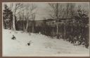
| Date: | 1915 |
|---|---|
| Description: | View looking north over Fish Creek Bay, with Hen Island and Peninsula State Park in the background. There is snow on the ground, and evergreens and bare bi... |

| Date: | 1915 |
|---|---|
| Description: | Elevated view over a heavily wooded area to Fish Creek Harbor and Hen Island, with Peninsula State Park in the background. |

| Date: | 1740 |
|---|---|
| Description: | Engraved and hand-colored map of the Iberian peninsula as a theater of war during the War of the Spanish Succession (1701-1714). The map is dedicated to Ki... |

| Date: | 1785 |
|---|---|
| Description: | Map of part of North America engraved and hand-colored (the light brown design is a superposition of the map and cartouche derived from the oxidation of th... |
| Date: | 1910 |
|---|---|
| Description: | Color enhanced aerial view of the village of DeSoto, looking north along the Mississippi River. Caption reads: "Bird's Eye View of the Village of De Soto, ... |
| Date: | 1920 |
|---|---|
| Description: | Black and white photographic postcard view of De Soto, taken from the cliff south of town, looking north along the Mississippi River. Caption reads: "A Vie... |
If you didn't find the material you searched for, our Library Reference Staff can help.
Call our reference desk at 608-264-6535 or email us at:
