 Filter: Categories of Wisconsin Historical Images
Filter: Subject of Landforms
Filter: Subject of peninsulas
Filter: Categories of Wisconsin Historical Images
Filter: Subject of Landforms
Filter: Subject of peninsulas

| Date: | 1908 |
|---|---|
| Description: | A panoramic aerial view of the Isthmus taken from a kite. Lake Mendota is to the right in the background with Picnic Point jutting into the lake. The photo... |
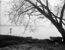
| Date: | 05 05 1931 |
|---|---|
| Description: | View across Lake Mendota towards Picnic Point, framed by a willow tree, and a rowboat pulled up on the shoreline. |

| Date: | 1924 |
|---|---|
| Description: | Aerial view of Madison's Willow Beach towards the University of Wisconsin-Madison campus, downtown Madison, and Lake Monona. |

| Date: | 1910 |
|---|---|
| Description: | Observatory building on hill on the University of Wisconsin-Madison campus. Lake Mendota and Picnic Point are in the background. |
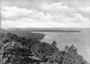
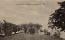
| Date: | |
|---|---|
| Description: | Elevated view of Shanty Bay at Peninsula State Park, established in 1910. |
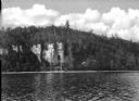
| Date: | |
|---|---|
| Description: | View across water towards Eagle Cliff at Peninsula State Park, established in 1910. |

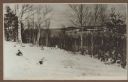
| Date: | 1915 |
|---|---|
| Description: | Elevated view, looking north, from the Hotz family compound near the bluff entrance to Fish Creek. Evergreens and bare birch trees stand in the foreground,... |
| Date: | 1915 |
|---|---|
| Description: | View looking north over Fish Creek Bay, with Hen Island and Peninsula State Park in the background. There is snow on the ground, and evergreens and bare bi... |

| Date: | 1915 |
|---|---|
| Description: | Elevated view over a heavily wooded area to Fish Creek Harbor and Hen Island, with Peninsula State Park in the background. |
| Date: | 1915 |
|---|---|
| Description: | View down hill towards a man fishing from the pier at Nelson Point in Peninsula State Park. Fish Creek is seen across the bay. Dr. Welcker's Casino is the ... |

| Date: | 1951 |
|---|---|
| Description: | Water depths shown by bathymetric tints and soundings. Relief shown by contours. "Depths in feet." "Aids to navigation corrected to May 4, 1951." On verso:... |

| Date: | |
|---|---|
| Description: | Exterior of the menu for Paul's Cafe, with a bird's-eye view map of "Washburn's Natural Deep Water Land Locked Harbor," Chequamegon Bay, and the Apostle Is... |
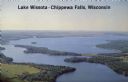
| Date: | 1950 |
|---|---|
| Description: | Aerial view, looking northwest, three miles east of Chippewa Falls, Wisconsin. Big Lake Wissota is seen across from Highway 29 in this color postcard, with... |

| Date: | 08 20 1951 |
|---|---|
| Description: | Elevated view through trees of the Lake Michigan shoreline. A birch tree with two trunks is in the foreground. |

| Date: | |
|---|---|
| Description: | Elevated view of the park and the Lake Michigan shoreline. Description on the photograph record reads: "Looking Northeast from Sven's Tower." |

| Date: | 1915 |
|---|---|
| Description: | View looking down at an Austrian fortress officer lying in the grass at the crest of a ridge line, using it as an observation post while looking for the en... |

| Date: | 1980 |
|---|---|
| Description: | Aerial shot directly over Picnic Point. Boats are in the lake. Text on reverse reads: "Picnic Point — A peninsula of the University of Wisconsin campus jut... |
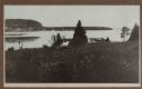
| Date: | |
|---|---|
| Description: | Sepia-toned photographic postcard view looking out towards the Picnic Point Peninsula jutting out into Lake Mendota. A walking path is on the left Caption ... |
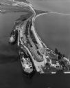
| Date: | 09 17 1948 |
|---|---|
| Description: | Aerial view of two Lake Michigan ferries tied up at harbor slips. The eastern terminus of the Green Bay Route was the Lake Michigan port city of Kewaunee. ... |
If you didn't find the material you searched for, our Library Reference Staff can help.
Call our reference desk at 608-264-6535 or email us at: