 Filter: Categories of Wisconsin Historical Images
Filter: Subject of Landforms
Filter: Subject of land
Filter: County of Dane
Filter: Categories of Wisconsin Historical Images
Filter: Subject of Landforms
Filter: Subject of land
Filter: County of Dane

| Date: | 02 06 1948 |
|---|---|
| Description: | Aerial view of west side, looking south along Glenway Street. Visible are the reservoir, Lake Wingra, Forest Hill and Resurrection Cemetery, Hoyt Park. Maj... |

| Date: | 02 06 1948 |
|---|---|
| Description: | Aerial photograph looking northwest across the reservoir on Glenway Street. Featured are Hoyt and Quarry Parks, Resurrection Cemetery. Major streets are Fr... |

| Date: | 02 06 1948 |
|---|---|
| Description: | Looking north along Glenway Street. Visible are the reservoir, Hoyt and Quarry Parks, Resurrection and Forest Hill Cemeteries, Rentschler Greenhouses, Fore... |

| Date: | 02 06 1948 |
|---|---|
| Description: | Looking southeast across Speedway Road. Visible are the reservoir on Glenway Street, Hoyt Park, Resurrection and Forest Hill cemeteries, Glenway Golf cours... |

| Date: | 02 06 1948 |
|---|---|
| Description: | Looking east along Regent Street with snow on the ground. Visible are Lake Wingra, Monona Bay, railroad causeway across Monona, Lake Mendota, Hoyt Park, We... |

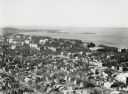
| Date: | |
|---|---|
| Description: | Elevated view looking northwest across Lake Mendota and the isthmus from the Wisconsin State Capitol dome. |
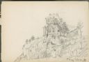
| Date: | 08 07 1885 |
|---|---|
| Description: | House on rock outcropping. The house has two chimneys and is two stories high with porch at left, three windows on first story, one visible on second story... |

| Date: | 08 06 1948 |
|---|---|
| Description: | Elevated view of west side neighborhood showing East Hill Trailer Camp, 451 N. Midvale Boulevard, at the corner of University Avenue and Midvale Boulevard. |
| Date: | 08 06 1948 |
|---|---|
| Description: | Elevated view of west side neighborhood showing houses to the east of Midvale Boulevard. |

| Date: | 1910 |
|---|---|
| Description: | Aerial View of University of Wisconsin-Madison College of Agriculture. Lake Mendota with Picnic Point is in the background. |

| Date: | 1908 |
|---|---|
| Description: | Aerial View of University of Wisconsin-Madison College of Agriculture. Lake Mendota with Picnic Point is in the background. |

| Date: | 1900 |
|---|---|
| Description: | Aerial View of University of Wisconsin-Madison College of Agriculture. Lake Mendota with Picnic Point is in the background. |

| Date: | 1946 |
|---|---|
| Description: | University of Wisconsin-Madison campus on isthmus, including the Agricultural campus and men's dormitories. Part of Lake Mendota is in the top right corner... |
| Date: | 1946 |
|---|---|
| Description: | View towards southeast of the University of Wisconsin-Madison on isthmus. Lake Mendota is in the lower left corner, and Lake Monona is in the upper portion... |
| Date: | 1924 |
|---|---|
| Description: | University of Wisconsin-Madison lower campus and the surrounding neighborhoods. Lake Mendota and Picnic Point are in the background. |
| Date: | 1924 |
|---|---|
| Description: | University of Wisconsin-Madison aerial view overlooking the lower campus and surrounding neighborhoods. Lake Mendota and Picnic Point are in the background... |

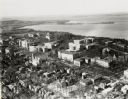
| Date: | 1946 |
|---|---|
| Description: | University of Wisconsin-Madison campus, looking south from Lake Mendota. Camp Randall stadium is in the upper right. |

| Date: | 1928 |
|---|---|
| Description: | University of Wisconsin-Madison, looking west. Lake Mendota and Picnic Point are in the upper right of the image. Bascom Hall, the Red Gym, the Wisconsin H... |

| Date: | 1961 |
|---|---|
| Description: | View over beltline of University of Wisconsin-Madison Arboretum along Lake Wingra. Lake Mendota is on upper left, and Lake Monona is on the right, with the... |
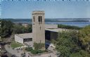
| Date: | 1963 |
|---|---|
| Description: | Elevated view of the Carillon Tower and Social Science Building, on the University of Wisconsin-Madison campus. Picnic Point and Lake Mendota are in the ba... |
If you didn't find the material you searched for, our Library Reference Staff can help.
Call our reference desk at 608-264-6535 or email us at: