 Filter: Categories of Wisconsin Historical Images
Filter: Subject of Landforms
Filter: Subject of harbors
Filter: Categories of Wisconsin Historical Images
Filter: Subject of Landforms
Filter: Subject of harbors

| Date: | 1910 |
|---|---|
| Description: | Bird's-eye view looking east, with Washburn Harbor at center and Chequamegon Bay in Lake Superior covering most of the upper image. Streets with buildings... |

| Date: | 1892 |
|---|---|
| Description: | Bird's-eye view of Chicago, with ships in the Lake Michigan harbor. |
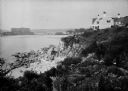
| Date: | 1930 |
|---|---|
| Description: | View along top of rocky cliff toward a home on the right overlooking the ocean, with a large building further down the curving shoreline in the distance. |
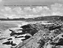
| Date: | 1925 |
|---|---|
| Description: | View along rocky coastline with crashing waves. Buildings are along the shoreline in the distance. Caption reads: "View from Ye Headland Inn. Trefethen, Ma... |

| Date: | |
|---|---|
| Description: | Hand-drawn map of the area at the time of Pilgrim landing, drawn by Charles Blaskowikz. Includes commemorative historical notes. |

| Date: | 1866 |
|---|---|
| Description: | Exterior of Fort Sumter. A cannon has fallen on the steep shoreline and waves are hitting the rocks. Plate 58 |
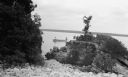
| Date: | 1925 |
|---|---|
| Description: | Elevated view of Fish Creek from the east; the bluff rises on the left, the harbor is on the right. The cottage in the foreground with pergola and lattice ... |
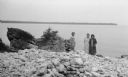
| Date: | 1942 |
|---|---|
| Description: | The photographer's daughter, Helen Hotz Schmid, left, and granddaughter, Margaret Schmid, right, pose at water's edge with Nenn Steck Hotz at Toft Point ne... |
| Date: | 1942 |
|---|---|
| Description: | View from rocky shoreline of two men fishing from a small boat near Toft Point. |
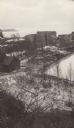
| Date: | 02 1925 |
|---|---|
| Description: | Elevated view of the abandoned town of Fayette. Snail Shell Harbor is in the foreground, with a low warehouse along the boat dock and empty buildings on th... |
| Date: | 02 1925 |
|---|---|
| Description: | Elevated view of the abandoned Jackson Iron Company furnace complex at Fayette, on the shore of Snail Shell Harbor. Lake Michigan is in the background. |
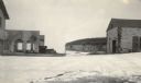
| Date: | 02 1925 |
|---|---|
| Description: | Dolomite cliffs along Snail Shell Harbor are seen in the background between the ruined buildings of the company store, left, and the machine shop on the gr... |
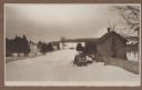
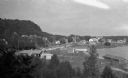
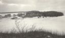
| Date: | 1915 |
|---|---|
| Description: | Winter scene from Egg Harbor Road (Highway 42) in Fish Creek looking north toward frozen Fish Creek Harbor with the bluffs in Peninsula State Park beyond. ... |

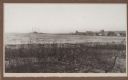
| Date: | 1915 |
|---|---|
| Description: | Elevated view over a heavily wooded area to Fish Creek Harbor and Hen Island, with Peninsula State Park in the background. |
| Date: | 1915 |
|---|---|
| Description: | View from shoreline over water towards a three-masted sailing vessel docked at Baileys Harbor pier. Houses and commercial buildings line the shore. |

| Date: | |
|---|---|
| Description: | Exterior of the menu for Paul's Cafe, with a bird's-eye view map of "Washburn's Natural Deep Water Land Locked Harbor," Chequamegon Bay, and the Apostle Is... |

| Date: | |
|---|---|
| Description: | Aerial view of harbor, with shipyards in the foreground and Superior in the background. Caption reads: "Aerial View of Harbor, Superior, Wisconsin." |
If you didn't find the material you searched for, our Library Reference Staff can help.
Call our reference desk at 608-264-6535 or email us at:


