 Filter: Categories of Wisconsin Historical Images
Filter: Subject of Landforms
Filter: Subject of fortification
Filter: Categories of Wisconsin Historical Images
Filter: Subject of Landforms
Filter: Subject of fortification

| Date: | 1835 |
|---|---|
| Description: | Little Lake Butte Des Morts just north of Lake Winnebago where Governor Lewis Cass of Michigan, and Thomas McKenney, head of the Bureau of Indian Affairs (... |

| Date: | 1864 |
|---|---|
| Description: | Fort Crawford was decommissioned in 1856, having outlived its usefulness as a frontier post. During the Civil War, however, it functioned as a military ho... |

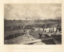
| Date: | 1864 |
|---|---|
| Description: | View across the Tennessee River toward the city and Cameron Hill, showing the military bridge and some Union Army installations put up following the occupa... |

| Date: | 1866 |
|---|---|
| Description: | Exterior of Fort Sumter. A cannon has fallen on the steep shoreline and waves are hitting the rocks. Plate 58 |
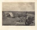
| Date: | 1864 |
|---|---|
| Description: | Confederate defenses surrounding the city. A tripod style configuration of rifles with a bag and canteen hanging from it is in the foreground. Plate 43<... |
| Date: | 1864 |
|---|---|
| Description: | One of the Confederate defenses surrounding the city. This view is of the inside of the earthworks which includes two cannons. A Union soldier sits as a lo... |

| Date: | 1864 |
|---|---|
| Description: | View looking out from one of the Confederate defenses around the outside of the city. Wooden palisades surround the earthworks. Houses and other buildings ... |

| Date: | 1866 |
|---|---|
| Description: | The south bank of the Chattahoochie River with a bridge spanning it. In the foreground are some battlements. Plate 33 |

| Date: | 1852 |
|---|---|
| Description: | A hand-colored map showing portions of present-day Iron and Vilas counties north of the Manitowish River as part of the Upper Peninsula of Michigan. The Wi... |

| Date: | 1867 |
|---|---|
| Description: | This 1867 manuscript map by Increase Lapham shows the topography and geology of the Blue Mounds region in the Town of Brigham in Iowa County and the towns ... |
If you didn't find the material you searched for, our Library Reference Staff can help.
Call our reference desk at 608-264-6535 or email us at: