 Filter: Categories of Wisconsin Historical Images
Filter: Subject of Landforms
Filter: Subject of factories
Filter: Categories of Wisconsin Historical Images
Filter: Subject of Landforms
Filter: Subject of factories

| Date: | 1867 |
|---|---|
| Description: | Birds-eye drawing of Appleton, Outagamie Co., depicting street names and street layout, houses, the Fox River, the court house, jail, school houses, Lawren... |

| Date: | 1891 |
|---|---|
| Description: | Bird's-eye view of Eau Claire. |

| Date: | 1893 |
|---|---|
| Description: | Bird's-eye map of Jefferson, looking north. Crayfish River at left and center, Rock River from upper center to bottom center, joins at left of center; thir... |

| Date: | 12 21 1882 |
|---|---|
| Description: | Bird's-eye map of Kaukauna, from the Appleton Post Annual Review. |

| Date: | 1910 |
|---|---|
| Description: | Bird's-eye view looking east, with Washburn Harbor at center and Chequamegon Bay in Lake Superior covering most of the upper image. Streets with buildings... |

| Date: | |
|---|---|
| Description: | View down hill of York Iron Works. On the left are charcoal kilns, and in the far background is the town. |
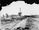
| Date: | |
|---|---|
| Description: | York Iron Works with a view of the blast furnace. On the hill is the boardinghouse and the dance hall. A man is working near the railroad cars, and other p... |
If you didn't find the material you searched for, our Library Reference Staff can help.
Call our reference desk at 608-264-6535 or email us at: