Filter: Categories of Wisconsin Historical Images
Filter: Subject of Landforms
Filter: Subject of botany
Filter: Categories of Wisconsin Historical Images
Filter: Subject of Landforms
Filter: Subject of botany
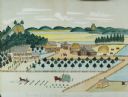
| Date: | 1875 |
|---|---|
| Description: | Seifert's watercolor is fairly large, measuring 27" wide by 21" high, and provides a detailed depiction of a nineteenth century Wisconsin farm. The small s... |

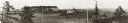
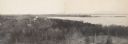
| Date: | 10 1905 |
|---|---|
| Description: | Elevated view from Reservoir Bluff to the east of the town. The bluffs of Iowa can be seen in the distance. |
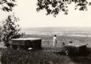
| Date: | 1925 |
|---|---|
| Description: | Brisbois grave, tomb of Michael Brisbois. A woman is standing behind the graves, looking out to Prairie du Chien and the Mississippi River. |

| Date: | 1915 |
|---|---|
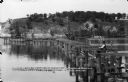
| Description: | Elevated view of Pontoon Bridge. Caption reads: "Largest Pontoon Bridge in the U.S. Scene at the Tri Cities, North and South McGergor and Prairie du Chien.... |

| Date: | 1950 |
|---|---|
| Description: | Elevated view of the bridge across the Mississippi River between Prairie du Chien, Wisconsin and Marquette, Iowa. Caption reads: "Suspension Bridge Between... |

| Date: | 1839 |
|---|---|
| Description: | Shows locations of cities, towns, villages, post hamlets, canals, rail and stage roads. Includes table of steamboat routes and distances; vignette of "Maid... |

| Date: | 1930 |
|---|---|
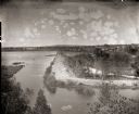
| Description: | Aerial view looking east at Mt. Trempealeau from Brady's Bluff in Perrot State Park. The Mississippi River is visible along the bluffs at upper left, and t... |

| Date: | 1869 |
|---|---|
| Description: | Increase A. Lapham in the foreground of a rock formation in Taylor's Glen, with A. Holly sitting on a rock in the background. |
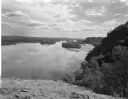
| Date: | 08 03 1946 |
|---|---|
| Description: | View of the Wisconsin River from Cactus Bluff. |
| Date: | |
|---|---|
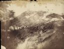
| Description: | The Battle of Chattanooga from the Milwaukee-based American Panoramic Company's cyclorama "The Storming of Missionary Ridge." |
| Date: | |
|---|---|
| Description: | Panoramic photograph from top of Bascom Hall facing northwest, showing Picnic Point on the University of Wisconsin campus. Washburn Observatory visible to ... |
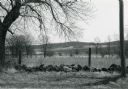
| Date: | |
|---|---|
| Description: | Kettle Moraine State Forest with moraines. A fence line partially consisting of glacial erratic rocks is visible in the foreground. |
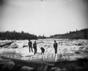
| Date: | 1876 |
|---|---|
| Description: | Three men and a dog are standing on thick chunks of ice looking over logs on an icy river. |
| Date: | 05 19 1895 |
|---|---|
| Description: | A view from the bluff of group of men on the dredge bank of Buffalo Lake. |
| Date: | 05 19 1895 |
|---|---|
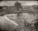
| Description: | Elevated view of the dam on the Fox River at Buffalo Lake. Houses and other buildings are visible in the background. |
| Date: | 06 19 1911 |
|---|---|
| Description: | Looking west over the Wisconsin River at the unfinished narrow gauge railroad trestle built for construction of the dam. Two pile drivers are seen in the a... |

| Date: | |
|---|---|
| Description: | Steamboat near a cliff on the Wisconsin River, presumably in the Wisconsin Dells. |
| Date: | 06 13 1913 |
|---|---|
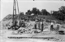
| Description: | Workmen and machinery at the quarry on Blackhawk Bluff. The gravel was used in construction of the power dam. |
If you didn't find the material you searched for, our Library Reference Staff can help.
Call our reference desk at 608-264-6535 or email us at: