 Filter: Categories of Wisconsin Historical Images
Filter: Subject of Landforms
Filter: County of Dane
Filter: Categories of Wisconsin Historical Images
Filter: Subject of Landforms
Filter: County of Dane
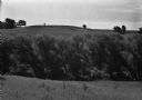
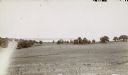
| Date: | 06 19 1960 |
|---|---|
| Description: | A row of willows resides between two crop fields. There is a hill in the background. |
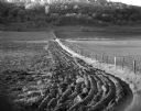
| Date: | 05 30 1960 |
|---|---|
| Description: | View down valley of newly plowed field at the juncture of two fence lines. The farmland belongs to Mr. Carl Meier. A tree-filled ridge is visible in the ba... |

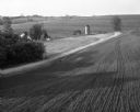
| Date: | 05 22 1960 |
|---|---|
| Description: | View of a newly planted field on a hillside. The edge of the field is shaded by a tree-lined ridge. |

| Date: | 07 10 1960 |
|---|---|
| Description: | View of a rolling field in a dense fog. A wire fence with wooden posts stands in the foreground and a group of trees grow in the field. |

| Date: | 11 06 1960 |
|---|---|
| Description: | View across field of a farm on a tree-lined hillside. |
| Date: | 06 1967 |
|---|---|
| Description: | Elevated view over plowed field and dirt road toward a farm with a farmhouse, barn, silo and other outbuildings residing in a sloping valley. |
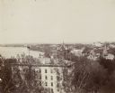
| Date: | 1897 |
|---|---|
| Description: | Elevated view of North Hall on the University of Wisconsin-Madison campus. Science Hall, Lake Mendota and the city of Madison on the isthmus are visible in... |
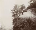
| Date: | 1894 |
|---|---|
| Description: | Elevated view of three women and a young girl standing at the edge of a small cliff on the shores of Lake Mendota. Various shrubs and small trees grow on t... |
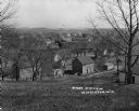
| Date: | |
|---|---|
| Description: | View of town taken from the top of a hill. |

| Date: | 1940 |
|---|---|
| Description: | Aerial view of the west side of the University of Wisconsin-Madison Campus looking towards Bascom Hill. Lake Mendota is in the background on the right. |
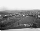
| Date: | 1916 |
|---|---|
| Description: | Bird's-eye view of town. Fields, with farms and fences, surround the town made up of numerous dwellings and a church. |
| Date: | 1900 |
|---|---|
| Description: | View downhill through pastures towards the northwest looking across Lake Mendota's University Bay with Picnic Point in the background. |
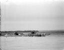
| Date: | 05 22 1954 |
|---|---|
| Description: | Two nine-men rowing crews racing on Lake Mendota as motor boats full of spectators are looking on. It was the Harvard crew's first visit to Madison and the... |

| Date: | 1906 |
|---|---|
| Description: | Topographical map of Turville Point and lands to the South to Nine Springs Creek. |
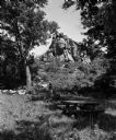
| Date: | 06 27 1954 |
|---|---|
| Description: | Two people walk near a large rock formation in a wooded area with a picnic table in the foreground. The occasion was the opening of a new wayside park loca... |
| Date: | |
|---|---|
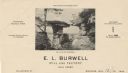
| Description: | Letterhead of E.L. Burrell, mill and factory sale agent in Madison, Wisconsin, with a center halftone image of Wisconsin Dells with a drawn-in group of men... |

| Date: | |
|---|---|
| Description: | Entrance to Black Hawk Cave on Lake Mendota, allegedly the hiding place of Chief Black Hawk. |

| Date: | 1900 |
|---|---|
| Description: | A Hydrographic map of Lake Mendota that shows the depths of the lake through contour lines and cross sections of the lake. Also shown in the map are the ad... |

| Date: | 1953 |
|---|---|
| Description: | A map of Lake Mendota that shows depths and the locations of various species of fish in lake. The maps also identifies a number of selected roads and stree... |

| Date: | 1867 |
|---|---|
| Description: | This 1867 manuscript map by Increase Lapham shows the topography and geology of the Blue Mounds region in the Town of Brigham in Iowa County and the towns ... |
If you didn't find the material you searched for, our Library Reference Staff can help.
Call our reference desk at 608-264-6535 or email us at: