 Filter: Categories of Wisconsin Historical Images
Filter: Subject of Landforms
Filter: County of Dane
Filter: Categories of Wisconsin Historical Images
Filter: Subject of Landforms
Filter: County of Dane

| Date: | |
|---|---|
| Description: | View of Picnic Point in the winter. The trees are bare, and ice and snow are on the lake. |

| Date: | 1919 |
|---|---|
| Description: | Aerial view looking north over Lake Monona towards the Wisconsin State Capitol on the isthmus. Lake Mendota is in the background. |

| Date: | |
|---|---|
| Description: | Aerial view looking southwest towards the Wisconsin State Capitol on the Capitol Square. Lake Wingra and Lake Monona are in the background. |

| Date: | |
|---|---|
| Description: | View between trees from Willow Drive of the sun setting over Lake Mendota. |

| Date: | |
|---|---|
| Description: | Aerial view over Monona Bay showing two railroads crossing in the center. Olin Park is on the top left. |
| Date: | 1908 |
|---|---|
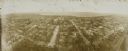
| Description: | Kite aerial panoramic photograph of the central business district. In the distance is Lake Mendota. The fire damaged Wisconsin State Capitol is in the cent... |

| Date: | |
|---|---|
| Description: | Text on reverse reads: "View of downtown Madison and Capitol Square from the air. In the foreground are Law Park and Lake Monona, in the background Lake Me... |

| Date: | |
|---|---|
| Description: | Aerial view of the Isthmus from over Lake Monona. The Wisconsin State Capitol and Lake Mendota are in the background. In the foreground is John Nolen Drive... |
| Date: | 1980 |
|---|---|
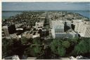
| Description: | Elevated view of East Washington Avenue from the Wisconsin State Capitol. There is a glass bank building on the right side of East Washington Avenue. The Y... |

| Date: | 1980 |
|---|---|
| Description: | Aerial view of Capitol Square and the surrounding central isthmus. Lake Monona is on the right. |
| Date: | |
|---|---|
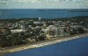
| Description: | Color aerial postcard of the Isthmus from over Lake Monona. John Nolen Drive is along the shoreline in the foreground. The Wisconsin State Capitol is in th... |

| Date: | 1890 |
|---|---|
| Description: | Plat map of Madison, T7N R9E, including portions of the towns of Blooming Grove and Burke. Includes inset maps of South Madison, Quarrytown, Marril Park, a... |

| Date: | 1980 |
|---|---|
| Description: | Aerial shot directly over Picnic Point. Boats are in the lake. Text on reverse reads: "Picnic Point — A peninsula of the University of Wisconsin campus jut... |
| Date: | |
|---|---|
| Description: | Sepia-toned photographic postcard view looking out towards the Picnic Point Peninsula jutting out into Lake Mendota. A walking path is on the left Caption ... |

| Date: | 1908 |
|---|---|
| Description: | Bird's-eye view showing Lake Mendota, Lake Monona, Lake Waubesa, Lake Wingra and Lake Kegonsa. Madison has only the isthmus developed, and there are settle... |
| Date: | 1979 |
|---|---|
| Description: | Text on reverse reads: "Madison, Wisconsin photographed on infrared film at an altitude of 22 miles from a NASA research aircraft. Red = vegetation Blue ... |

| Date: | |
|---|---|
| Description: | Elevated view of State Street from the Capitol. A streetcar is coming up the street, and automobiles are parked along the curbs. Lake Mendota is in the bac... |

| Date: | 1908 |
|---|---|
| Description: | A Sanborn map of the isthmus, which includes the map key. |
| Date: | 05 13 1961 |
|---|---|
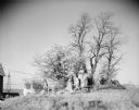
| Description: | View of several trees growing behind a rocky outcropping. In the background on the left is a farmhouse and farm buildings, and a tower for what may be a wi... |

| Date: | 08 10 1910 |
|---|---|
| Description: | Text on front reads: "Cedar Point, Lake Kegonsa." Cottages, docks and trees on the shore of a bay, with the shoreline curving to the right and a point of l... |
If you didn't find the material you searched for, our Library Reference Staff can help.
Call our reference desk at 608-264-6535 or email us at: