 Filter: Categories of Wisconsin Historical Images
Filter: Subject of Landforms
Filter: County of Dane
Filter: Categories of Wisconsin Historical Images
Filter: Subject of Landforms
Filter: County of Dane

| Date: | 1896 |
|---|---|
| Description: | Shows pipes of various sizes, hydrants with hydrant pressure, valves, wells, projected lines, and suction pipes. Differs from earlier versions by inclusion... |

| Date: | 1909 |
|---|---|
| Description: | Streets, Lake Wingra, Lake Mendota, and Lake Monona are all labelled. Map reads: "The present park system of Madison comprises 150 acres of improved parks,... |
| Date: | |
|---|---|
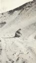
| Description: | A woman, Grace, digs in the sand as she kneels in a sand pit near the intersection of Fish Hatchery Road and Park Street. A note on the back of the photogr... |
| Date: | |
|---|---|
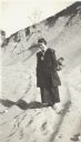
| Description: | Florance Trask poses standing in a sand pit located near the intersection of Fish Hatchery Road and Park Street. Another woman, Grace, can be seen digging ... |

| Date: | |
|---|---|
| Description: | A woman, Grace, smiles as she poses while standing in a sand pit near the intersection of Fish Hatchery Road and Park Street. A note on the back of the pho... |
| Date: | 1930 |
|---|---|
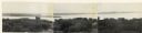
| Description: | Panoramic elevated view to the northwest from the Capitol Square. |

| Date: | 1861 |
|---|---|
| Description: | The township of Primrose, which is a detail from the plat map of Dane County. |

| Date: | 1861 |
|---|---|
| Description: | The township of Montrose, which is a detail from a Dane County plat map. |

| Date: | 1928 |
|---|---|
| Description: | View from grassy hill of uptown Cross Plains. The Catholic Church (St. Francis Xavier) is on the right, and farmhouses and other buildings are among fields... |

| Date: | 1954 |
|---|---|
| Description: | Aerial view of the west side of Madison showing newly constructed homes and homes under construction featured in the Parade of Homes. The main road through... |

| Date: | |
|---|---|
| Description: | Letterhead of Johnson & Melaas, merchant tailors and cloth dealers, "Buyers of wool and Wisconsin leaf tobacco," with an engraving of a waterfront view of ... |

| Date: | |
|---|---|
| Description: | Detail from a drawing of a plan for the isthmus. |
| Date: | |
|---|---|
| Description: | That morning is adrift in passing; it cannot last the day. Those years are anchored to each other; there is no other way. |

| Date: | 1900 |
|---|---|
| Description: | Elevated view of Madison through trees. Lake Mendota, buildings of the University of Wisconsin-Madison, including the Washburn Observatory are along the sh... |

| Date: | 1960 |
|---|---|
| Description: | This map shows block numbers, tract numbers, tract boundaries, city limits, local streets, railroads, Lake Mendota, and Lake Monona. |

| Date: | 1899 |
|---|---|
| Description: | A plat map showing Lake Monona, the isthmus in Madison, and the towns of Burke and Blooming Grove. |

| Date: | 05 24 1961 |
|---|---|
| Description: | View of small domed hill on Highway 19, surrounded by fields. |
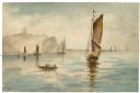
| Date: | 1905 |
|---|---|
| Description: | Watercolor painting of boats and sailboats on Lake Mendota, looking towards Maple Bluff, perhaps from Governor's Island or Rocky Roost. |
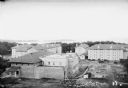
| Date: | 1925 |
|---|---|
| Description: | Elevated view of dormitories nearing construction completion on the University of Wisconsin-Madison campus. Adams, Van Hise and Tripp Halls are in the fore... |

| Date: | |
|---|---|
| Description: | Elevated view from the Wisconsin State Capitol of the old water tower, and an expansive view of the city with church steeples, houses, commercial buildings... |
If you didn't find the material you searched for, our Library Reference Staff can help.
Call our reference desk at 608-264-6535 or email us at: