 Filter: Categories of Wisconsin Historical Images
Filter: Subject of Landforms
Filter: County of Dane
Filter: Year of 1900-1999
Filter: Year of 1900-1909
Filter: Categories of Wisconsin Historical Images
Filter: Subject of Landforms
Filter: County of Dane
Filter: Year of 1900-1999
Filter: Year of 1900-1909

| Date: | 1908 |
|---|---|
| Description: | Colored map showing a panoramic view of Madison in great detail. The Wisconsin State Capitol is located at the center, with Lake Mendota in the background ... |

| Date: | 1908 |
|---|---|
| Description: | A panoramic aerial view of the Isthmus taken from a kite. Lake Mendota is to the right in the background with Picnic Point jutting into the lake. The photo... |

| Date: | 05 09 1908 |
|---|---|
| Description: | Kite aerial panoramic photograph of the central business district. In the distance is Lake Mendota. The fire damaged Wisconsin State Capitol is in the cent... |
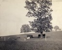
| Date: | 1900 |
|---|---|
| Description: | Fenced-in, the cattle find a grassy pasture of Observatory Hill below Washburn Observatory on the University of Wisconsin-Madison campus. |
| Date: | 1900 |
|---|---|
| Description: | Elevated view of Observatory Hill on the University of Wisconsin Madison campus of the United States National, Wisconsin State Farm Experiment Station, Pro... |

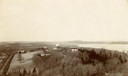
| Date: | 1909 |
|---|---|
| Description: | View from the University of Wisconsin service building smokestack of south Madison, including Mills Street, Mound Street, and the Greenbush. Lake Monona is... |

| Date: | 1908 |
|---|---|
| Description: | Aerial View of University of Wisconsin-Madison College of Agriculture. Lake Mendota with Picnic Point is in the background. |

| Date: | 1900 |
|---|---|
| Description: | Aerial View of University of Wisconsin-Madison College of Agriculture. Lake Mendota with Picnic Point is in the background. |
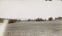
| Date: | 1900 |
|---|---|
| Description: | View downhill through pastures towards the northwest looking across Lake Mendota's University Bay with Picnic Point in the background. |

| Date: | 1906 |
|---|---|
| Description: | Topographical map of Turville Point and lands to the South to Nine Springs Creek. |

| Date: | 1900 |
|---|---|
| Description: | A Hydrographic map of Lake Mendota that shows the depths of the lake through contour lines and cross sections of the lake. Also shown in the map are the ad... |

| Date: | 1909 |
|---|---|
| Description: | Streets, Lake Wingra, Lake Mendota, and Lake Monona are all labelled. Map reads: "The present park system of Madison comprises 150 acres of improved parks,... |

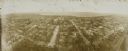
| Date: | 1900 |
|---|---|
| Description: | Elevated view of Madison through trees. Lake Mendota, buildings of the University of Wisconsin-Madison, including the Washburn Observatory are along the sh... |

| Date: | 1905 |
|---|---|
| Description: | Watercolor painting of boats and sailboats on Lake Mendota, looking towards Maple Bluff, perhaps from Governor's Island or Rocky Roost. |
| Date: | 1908 |
|---|---|
| Description: | Kite aerial panoramic photograph of the central business district. In the distance is Lake Mendota. The fire damaged Wisconsin State Capitol is in the cent... |

| Date: | 1908 |
|---|---|
| Description: | Bird's-eye view showing Lake Mendota, Lake Monona, Lake Waubesa, Lake Wingra and Lake Kegonsa. Madison has only the isthmus developed, and there are settle... |

| Date: | 1908 |
|---|---|
| Description: | A Sanborn map of the isthmus, which includes the map key. |
If you didn't find the material you searched for, our Library Reference Staff can help.
Call our reference desk at 608-264-6535 or email us at: