 Filter: Categories of Wisconsin Historical Images
Filter: Subject of Land use, Urban
Filter: Year of 1800-1899
Filter: Year of 1880-1889
Filter: Categories of Wisconsin Historical Images
Filter: Subject of Land use, Urban
Filter: Year of 1800-1899
Filter: Year of 1880-1889
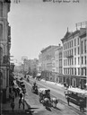
| Date: | 1885 |
|---|---|
| Description: | Elevated view down East Water Street from Wisconsin Avenue, with buildings, people, and street traffic including horse-drawn vehicles and a horse-drawn str... |
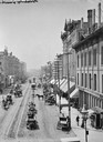
| Date: | 1885 |
|---|---|
| Description: | Elevated view of buildings and street traffic. |
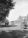
| Date: | 1885 |
|---|---|
| Description: | View looking up Grand Avenue from 9th Street toward two horse-drawn wagons and a horse-drawn streetcar on the tree-lined street. The wagon on the right is ... |
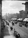
| Date: | 1885 |
|---|---|
| Description: | Elevated view of West Water Street from Grand Avenue of horse-drawn vehicles, pedestrians, buildings, storefronts and power lines. |
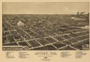
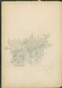
| Date: | 1886 |
|---|---|
| Description: | Bird's-eye map of Antigo, county Seat of Langlade County, population 2500. |
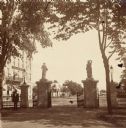
| Date: | 1880 |
|---|---|
| Description: | View of the gate to the Wisconsin State Capitol grounds, looking out to the street. On the left on the opposite side of the street is a building with a sig... |
| Date: | 1884 |
|---|---|
| Description: | Like many early settlements of southeastern Wisconsin, Clinton was founded in 1836 by Yankees--immigrants from New England and New York. |
| Date: | 07 03 1886 |
|---|---|
| Description: | The east side of the Schlitz Palm Garden at N. 3rd Street, south of W. Wisconsin Avenue. The Schlitz Palm Garden opened on July 3, 1886 and was one of the ... |
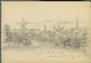
| Date: | 08 26 1885 |
|---|---|
| Description: | Pencil on paper; view from Bascom Hill, with buildings, churches, on the right side of street, Wisconsin State Capitol in background, with trees surroundin... |
| Date: | 09 01 1885 |
|---|---|
| Description: | Pencil on paper; Elevated view of building on street corner with horse-drawn delivery wagon in front. Tall trees line the two streets. Building is two st... |
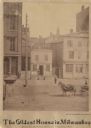
| Date: | 1884 |
|---|---|
| Description: | Subheading states the center building to be the oldest house in Milwaukee, and built by Matthias Stein in January 1838. The home is only two stories tall,... |
| Date: | 1886 |
|---|---|
| Description: | Stereograph of a man on Main Street, created by Van Schaick or his colleague, Thomas T. McAdam. |
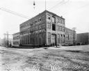
| Date: | 1886 |
|---|---|
| Description: | Exterior view of one of the first Pawling & Harnischfeger machine shops. The building was built in 1886 on the corner of South First Street and East Oregon... |

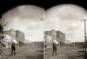
| Date: | 1886 |
|---|---|
| Description: | Stereograph of a man on Main Street in Black River Falls, ca. 1886, created by Van Schaick or his colleague, Thomas T. McAdam. |
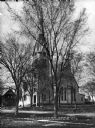
| Date: | 1880 |
|---|---|
| Description: | View of the facade and side of the Congregational Church, partially obscured by trees. The bell tower doubles as a clock tower. |

| Date: | 1885 |
|---|---|
| Description: | Fire insurance map of the McCormick Reaper Works, a factory of the McCormick Harvesting Machine Company. |

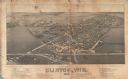
| Date: | 1880 |
|---|---|
| Description: | A map of Milwaukee which includes a city street guide. |
If you didn't find the material you searched for, our Library Reference Staff can help.
Call our reference desk at 608-264-6535 or email us at:
