 Filter: Categories of Wisconsin Historical Images
Filter: Subject of Land use, Urban
Filter: Year of 1800-1899
Filter: Categories of Wisconsin Historical Images
Filter: Subject of Land use, Urban
Filter: Year of 1800-1899

| Date: | 1850 |
|---|---|
| Description: | This map of the Town of Lake is ink and pencil on paper and shows lots and acreages, reserved land, and public squares. The bottom of the map includes a ke... |
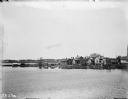
| Date: | 1897 |
|---|---|
| Description: | A view of Madison from a lake shoreline. Unknown location. |

| Date: | 1880 |
|---|---|
| Description: | A map of Milwaukee which includes a city street guide. |
If you didn't find the material you searched for, our Library Reference Staff can help.
Call our reference desk at 608-264-6535 or email us at: