 Filter: Categories of Wisconsin Historical Images
Filter: Subject of Land use, Urban
Filter: Year of 1800-1899
Filter: Type of Map or Atlas
Filter: Categories of Wisconsin Historical Images
Filter: Subject of Land use, Urban
Filter: Year of 1800-1899
Filter: Type of Map or Atlas
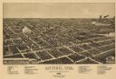
| Date: | 1886 |
|---|---|
| Description: | Bird's-eye map of Antigo, county Seat of Langlade County, population 2500. |

| Date: | 1892 |
|---|---|
| Description: | Bird's-eye view of Chicago, with ships in the Lake Michigan harbor. |

| Date: | 1892 |
|---|---|
| Description: | Bird's-eye view of the Columbian Exposition pavilions from the vantage point of Lake Michigan. Included is an inset of the Union Passenger Station (now Uni... |

| Date: | 1867 |
|---|---|
| Description: | Drawn map showing planned development of Cornell, including a couple of schools, Oakwood cemetery, the public square, and several bridges and dams. |
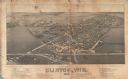
| Date: | 1884 |
|---|---|
| Description: | Like many early settlements of southeastern Wisconsin, Clinton was founded in 1836 by Yankees--immigrants from New England and New York. |

| Date: | 07 01 1836 |
|---|---|
| Description: | Original plat map of the town of Madison on the four lakes. |
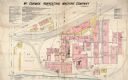
| Date: | 12 1898 |
|---|---|
| Description: | Fire insurance map showing the grounds and buildings of the McCormick Reaper Works, a factory operated by the McCormick Harvesting Machine Company. |

| Date: | 1885 |
|---|---|
| Description: | Fire insurance map of the McCormick Reaper Works, a factory of the McCormick Harvesting Machine Company. |

| Date: | 1829 |
|---|---|
| Description: | This map of Munnomonee is ink and pencil on tracing cloth. The map shows a plat of the town, local streets, highways, land donations for public use, and pa... |

| Date: | 1850 |
|---|---|
| Description: | This map of the Town of Lake is ink and pencil on paper and shows lots and acreages, reserved land, and public squares. The bottom of the map includes a ke... |

| Date: | 1880 |
|---|---|
| Description: | A map of Milwaukee which includes a city street guide. |
If you didn't find the material you searched for, our Library Reference Staff can help.
Call our reference desk at 608-264-6535 or email us at:
