 Filter: Categories of Wisconsin Historical Images
Filter: Subject of Land use, Urban
Filter: Subject of human settlements
Filter: Categories of Wisconsin Historical Images
Filter: Subject of Land use, Urban
Filter: Subject of human settlements
| Date: | 1900 |
|---|---|
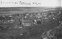
| Description: | View from bluff looking northwest at the town of Cassville. A church in the center is the dominant structure in the foreground. Caption reads: "Souvenir - ... |
| Date: | 1900 |
|---|---|
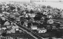
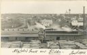
| Description: | Elevated view of Cassville and its residential area. Bottom text reads: "Souvenir, Cassville." Written at top right: "Cassvie Wis..... 190__." |
| Date: | 1900 |
|---|---|
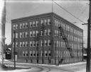
| Description: | The square, four-story brick Chippewa Shoe Company building, located at the intersection of Bay Street and River Street looking North. There is a fire esca... |
| Date: | 1910 |
|---|---|
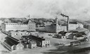
| Description: | An engraving of an elevated view of the Leinenkugel brewery, est. 1867, located at 5 Jefferson Avenue. |

| Date: | 1867 |
|---|---|
| Description: | Drawn map showing planned development of Cornell, including a couple of schools, Oakwood cemetery, the public square, and several bridges and dams. |

| Date: | 1955 |
|---|---|
| Description: | Aerial view of Cross Plains, with countryside surrounding and hills on the horizon. |

| Date: | 1950 |
|---|---|
| Description: | Aerial view of main street. There is a bridge with a stream flowing under it in the foreground. |
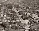
| Date: | 1950 |
|---|---|
| Description: | Aerial view of the main street of town. |
| Date: | 1957 |
|---|---|
| Description: | Aerial view of downtown with surrounding landscape. |
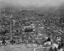
| Date: | 1957 |
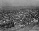
|---|---|
| Description: | Aerial view of town and the surrounding countryside. |
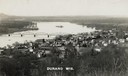
| Date: | 1910 |
|---|---|
| Description: | Elevated view of Durand from a high vantage point, looking towards the river. A bridge spans the river, and in the foreground just below the hill is a chur... |

| Date: | 1930 |
|---|---|
| Description: | Aerial view of city, with Eau Claire River is in the foreground with Milwaukee railroad bridge at left. Gillette Rubber Co. plant is in center with Omaha r... |

| Date: | 1922 |
|---|---|
| Description: | Aerial view of the Wisconsin State Capitol and Lake Monona. |

| Date: | 1957 |
|---|---|
| Description: | Aerial view of the north corner of Capitol Square looking toward Lake Mendota. The Belmont Hotel is featured prominently. |

| Date: | 1956 |
|---|---|
| Description: | Aerial view looking northeast from a point over the east end of Middleton, showing the west end of Lake Mendota (right mid-ground). Fox Bluff juts into the... |

| Date: | 1919 |
|---|---|
| Description: | Aerial view with the Wisconsin State Capitol in the foreground, and the tip of Monona Bay and Lake Wingra to the left, with horizon stretching into the dis... |

| Date: | 1955 |
|---|---|
| Description: | Aerial view of Atwood Avenue, looking west towards Winnebago Street and "Schenk's Corners." |
| Date: | 1906 |
|---|---|
| Description: | Elevated view of a sawmill and the distant town in the background. Stacks of logs are in the lumberyard. Along the bottom is a New Year's greeting in Germa... |

| Date: | 1930 |
|---|---|
| Description: | Aerial view of isthmus looking east toward Lake Mendota and the Wisconsin State Capitol, with Lake Monona and the horizon in the background. |

| Date: | 1953 |
|---|---|
| Description: | Aerial view looking southeast over Madison's near east side. The Eagles Club at 1236 Jenifer Street / 1221 Williamson Street is under construction in the ... |
If you didn't find the material you searched for, our Library Reference Staff can help.
Call our reference desk at 608-264-6535 or email us at: