 Filter: Categories of Wisconsin Historical Images
Filter: Subject of Land use, Urban
Filter: Subject of cities and towns
Filter: Categories of Wisconsin Historical Images
Filter: Subject of Land use, Urban
Filter: Subject of cities and towns
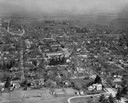
| Date: | 1957 |
|---|---|
| Description: | Aerial view of town and the surrounding countryside. |
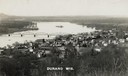
| Date: | 1910 |
|---|---|
| Description: | Elevated view of Durand from a high vantage point, looking towards the river. A bridge spans the river, and in the foreground just below the hill is a chur... |

| Date: | 1930 |
|---|---|
| Description: | Aerial view of city, with Eau Claire River is in the foreground with Milwaukee railroad bridge at left. Gillette Rubber Co. plant is in center with Omaha r... |

| Date: | 1922 |
|---|---|
| Description: | Aerial view of the Wisconsin State Capitol and Lake Monona. |

| Date: | 1957 |
|---|---|
| Description: | Aerial view of the north corner of Capitol Square looking toward Lake Mendota. The Belmont Hotel is featured prominently. |

| Date: | 1956 |
|---|---|
| Description: | Aerial view looking northeast from a point over the east end of Middleton, showing the west end of Lake Mendota (right mid-ground). Fox Bluff juts into the... |

| Date: | 1919 |
|---|---|
| Description: | Aerial view with the Wisconsin State Capitol in the foreground, and the tip of Monona Bay and Lake Wingra to the left, with horizon stretching into the dis... |

| Date: | 1955 |
|---|---|
| Description: | Aerial view of Atwood Avenue, looking west towards Winnebago Street and "Schenk's Corners." |
| Date: | 1906 |
|---|---|
| Description: | Elevated view of a sawmill and the distant town in the background. Stacks of logs are in the lumberyard. Along the bottom is a New Year's greeting in Germa... |

| Date: | 1930 |
|---|---|
| Description: | Aerial view of isthmus looking east toward Lake Mendota and the Wisconsin State Capitol, with Lake Monona and the horizon in the background. |

| Date: | 1953 |
|---|---|
| Description: | Aerial view looking southeast over Madison's near east side. The Eagles Club at 1236 Jenifer Street / 1221 Williamson Street is under construction in the ... |
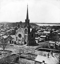
| Date: | |
|---|---|
| Description: | Elevated view of the First Congregational Church and chapel at the corner of North Fairchild Street and West Washington Avenue. The Gates of Heaven Synagog... |
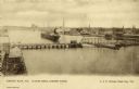
| Date: | 1900 |
|---|---|
| Description: | Looking North. Harbor with boats, bridge, and buildings. |
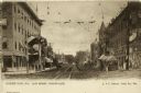
| Date: | 1890 |
|---|---|
| Description: | Main Street, looking east at storefronts. Booths with flags and bunting are set up on the sidewalk. Caption reads: "Green Bay, Wis. Main Street, Looking Ea... |
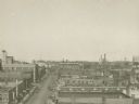
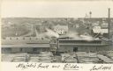
| Date: | 1920 |
|---|---|
| Description: | Elevated view of the commercial area along the east side of the Fox River. |
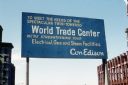
| Date: | 1969 |
|---|---|
| Description: | Con Edison billboard for the World Trade Center. The sign reads "To meet the needs of the spectacular twin-towered World Trade Center we're strengthening y... |

| Date: | 1969 |
|---|---|
| Description: | Close-up view of jackhammer operator during the construction of the World Trade Center. |
| Date: | 1969 |
|---|---|
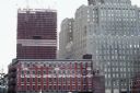
| Description: | One of the two towers of the World Trade Center during construction. |
| Date: | 1969 |
|---|---|
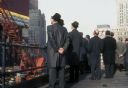
| Description: | Rear view of onlookers observing the construction of the World Trade Center towers. |
| Date: | 1969 |
|---|---|
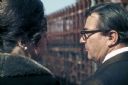
| Description: | A man and a woman (with a beehive hairstyle) observe the construction of the World Trade Center towers. |
If you didn't find the material you searched for, our Library Reference Staff can help.
Call our reference desk at 608-264-6535 or email us at: