 Filter: Categories of Wisconsin Historical Images
Filter: Subject of Land use, Urban
Filter: Subject of cities and towns
Filter: Subject of piers
Filter: Categories of Wisconsin Historical Images
Filter: Subject of Land use, Urban
Filter: Subject of cities and towns
Filter: Subject of piers

| Date: | 1892 |
|---|---|
| Description: | Bird's-eye view of Chicago, with ships in the Lake Michigan harbor. |

| Date: | 1892 |
|---|---|
| Description: | Bird's-eye view of the Columbian Exposition pavilions from the vantage point of Lake Michigan. Included is an inset of the Union Passenger Station (now Uni... |
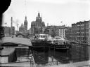
| Date: | |
|---|---|
| Description: | Elevated view of two Goodrich Line passenger ferries docked on the west bank of the Milwaukee River, north of the Clybourn Street bridge. The Pabst buildin... |
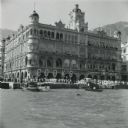
| Date: | 09 1951 |
|---|---|
| Description: | The large, ornamental office building of Thomas Cook and Sons on the waterfront in Hong Kong. The firm was one of the oldest and largest travel companies i... |

| Date: | 1891 |
|---|---|
| Description: | Color illustration of the grounds and buildings of the 1893 World's Fair or Columbian Exposition. |

| Date: | 1902 |
|---|---|
| Description: | This map is a chart of Milwaukee Harbor that displays local streets, bridges, roads, railroads, public buildings, businesses, factories, dry docks, parks, ... |
If you didn't find the material you searched for, our Library Reference Staff can help.
Call our reference desk at 608-264-6535 or email us at:
