 Filter: Categories of Wisconsin Historical Images
Filter: Subject of Land use, Urban
Filter: County of Milwaukee
Filter: Year of 1900-1999
Filter: Categories of Wisconsin Historical Images
Filter: Subject of Land use, Urban
Filter: County of Milwaukee
Filter: Year of 1900-1999
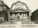
| Date: | 1918 |
|---|---|
| Description: | View from street of Willms home, 2025 S. 31st Street, Milwaukee. Home of Kunigunde (Dorn) Willms (1857-1941) and her daughters Anna (b. 1881) and Emma (189... |
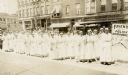
| Date: | 1918 |
|---|---|
| Description: | Group of women gathered at 2nd (now 7th St.) and Mitchell wearing light-colored dresses and hats. Each woman holds a U.S. flag. There is a sign to the righ... |

| Date: | 1938 |
|---|---|
| Description: | Children standing in line, boarding an International D-300 bus near what appears to be a school building. This bus was equipped with 165" Hicks body. |

| Date: | 1938 |
|---|---|
| Description: | Children standing in line, boarding an International D-300 bus near what appears to be a school buiding. This bus was equipped with 165" Hicks body. |

| Date: | 03 27 1937 |
|---|---|
| Description: | A man unloads buckets of paint from the back of an International D-30 truck owned by Pittsburgh Paint Products. |
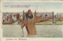
| Date: | 1914 |
|---|---|
| Description: | Postcard of the Milwaukee lakefront. In the foreground is an image of Neptune standing in Lake Michigan holding a trident in one hand and a beer stein in t... |

| Date: | 1939 |
|---|---|
| Description: | The Miller Brewing wagon, filled with barrels of beer, and a Miller delivery truck. The caption on the photograph reads "1855-1939". |

| Date: | 06 1905 |
|---|---|
| Description: | Stereograph elevated view of the Milwaukee Exposition Building. Handwritten text reads: "1634 Exposition Building." Printed text on postcard is partially c... |

| Date: | 1900 |
|---|---|
| Description: | Paved driveway, cobblestones, leading to the loading platform of the Pabst Brewing Co. In the background, three horses stand near a wagon loaded with barre... |

| Date: | 1947 |
|---|---|
| Description: | This map of Wauwatosa shows 10 zoning class types of land including residential, manufacturing, and business. The map also shows government buildings, some... |

| Date: | 1939 |
|---|---|
| Description: | This is a zoning map of Wauwatosa with a key of districts including agricultural, resident, business, commercial, and industrial. The map features labeled ... |

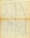
| Date: | 1940 |
|---|---|
| Description: | This map of Granville visually shows different types of zones: agricultural areas, "A" residence, "B" residence, local businesses, commercial and light man... |
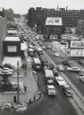
| Date: | 1956 |
|---|---|
| Description: | Elevated view looking on downtown street with traffic, in winter. |
| Date: | 1906 |
|---|---|
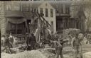
| Description: | Traffic to the J. Ohlenforst Bakery at 529 S. Sixth Street, in the Walker's Point neighborhood, is impeded by street construction. There are piles of grave... |
| Date: | 1906 |
|---|---|
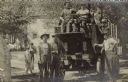
| Description: | John Hahn is leaning on a motorized moving van in the S. Sixth Street neighborhood of Walker's Point. At the steering wheel is a man, with another seated n... |

| Date: | 1902 |
|---|---|
| Description: | This map is a chart of Milwaukee Harbor that displays local streets, bridges, roads, railroads, public buildings, businesses, factories, dry docks, parks, ... |

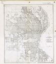
| Date: | 1964 |
|---|---|
| Description: | This map shows various zoning sections and includes labeled streets, parks, and cemeteries. The upper left corner contains a legend of land use. |
| Date: | 02 25 1965 |
|---|---|
| Description: | This blue line print map shows annexed land with ordinance numbers and dates. |

| Date: | 1965 |
|---|---|
| Description: | This map shows 32 zoning districts, house numbering system, parks, cemeteries, and Milwaukee County institutional buildings. |
| Date: | 12 11 1933 |
|---|---|
| Description: | This map shows residence, business, commercial, and industrial districts as well as streets, points of interest, and Lake Michigan. |
If you didn't find the material you searched for, our Library Reference Staff can help.
Call our reference desk at 608-264-6535 or email us at: