 Filter: Categories of Wisconsin Historical Images
Filter: Subject of Land use, Urban
Filter: County of Milwaukee
Filter: Subject of recreation areas
Filter: Categories of Wisconsin Historical Images
Filter: Subject of Land use, Urban
Filter: County of Milwaukee
Filter: Subject of recreation areas

| Date: | 1964 |
|---|---|
| Description: | Aerial view of the Milwaukee County Zoo grounds nearing its completion. |
| Date: | 11 29 1913 |
|---|---|
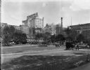
| Description: | Park near hotels and Gimbels building. Caption reads: "View N.E. from C. M. & St. P. Depot". Presently, it is Zeidler Union Square on W. Everett Street bet... |

| Date: | 09 24 1916 |
|---|---|
| Description: | Courthouse (now Cathedral) Square, looking northeast from N. Jefferson and E. Wells Street. People are sitting on benches in the park, with the courthouse ... |

| Date: | 1935 |
|---|---|
| Description: | The Court of Honor, Wisconsin Avenue. The statue, "The Victorious Charge," is in the center, with a church behind. On the left are more buildings going int... |

| Date: | 1940 |
|---|---|
| Description: | Swimming area with children and adults enjoying the weather, with the Tower Hotel is in the background. |
| Date: | 1970 |
|---|---|
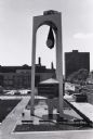
| Description: | Elevated view of Milwaukee Civic Center Plaza. Entire clock tower is visible, with the plaza around the base, and other buildings in the background. The c... |

| Date: | 1953 |
|---|---|
| Description: | Aerial view looking north from the foot of Milwaukee's main thoroughfare, Wisconsin Avenue. Lincoln Memorial Drive winds its way along the lagoon in Juneau... |

| Date: | |
|---|---|
| Description: | Elevated view of entrance to National Park on a city block. A road passes by a grove of evergreen trees lined up along the sidewalk, while two men work nea... |

| Date: | |
|---|---|
| Description: | An aerial view of downtown, including a baseball field in the lower left near a train station. |
| Date: | |
|---|---|
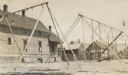
| Description: | A deserted playground with swing sets, slides, and ladders, in front of a group of buildings. There are two young boys near a dwelling in the background. |

| Date: | |
|---|---|
| Description: | Elevated exterior view of Everett Street Station, also called the New Passenger Station facing Fourth Ward Park (later renamed Zeidler Park). |

| Date: | 1939 |
|---|---|
| Description: | This is a zoning map of Wauwatosa with a key of districts including agricultural, resident, business, commercial, and industrial. The map features labeled ... |

| Date: | 1964 |
|---|---|
| Description: | This map shows various zoning sections and includes labeled streets, parks, and cemeteries. The upper left corner contains a legend of land use. |

| Date: | 1965 |
|---|---|
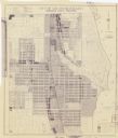
| Description: | This map shows 32 zoning districts, house numbering system, parks, cemeteries, and Milwaukee County institutional buildings. |
| Date: | 1956 |
|---|---|
| Description: | This blueline print map shows streets, pedestrian pathways, plans to widen existing streets, and streets and alleys vacated and to be vacated. The upper le... |

| Date: | 2005 |
|---|---|
| Description: | This map shows dams and falls, areas of portage, canoe and kayak access, boat launches, parking, restrooms, picnic areas, dining, rapid water, parks, and b... |
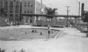
| Date: | 1938 |
|---|---|
| Description: | A view, looking south, at the intersection of West Mt. Vernon Avenue and North 65th Street. In the foreground is a shallow pool where children are playing,... |
If you didn't find the material you searched for, our Library Reference Staff can help.
Call our reference desk at 608-264-6535 or email us at: