 Filter: Categories of Wisconsin Historical Images
Filter: Subject of Land use, Urban
Filter: Creator Name of Vinje, Arthur M., 1888-1972
Filter: Community of Madison
Filter: Categories of Wisconsin Historical Images
Filter: Subject of Land use, Urban
Filter: Creator Name of Vinje, Arthur M., 1888-1972
Filter: Community of Madison
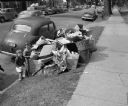
| Date: | 06 15 1948 |
|---|---|
| Description: | Uncollected garbage on South Hamilton Street being viewed by two children during a walkout strike by Local 236 Municipal Garage Department Union. |
| Date: | |
|---|---|
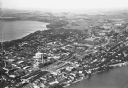
| Description: | Aerial view looking northeast towards the east side of Madison between Lake Monona and Lake Mendota, from Blair Street to the Yahara River. |
| Date: | 1930 |
|---|---|
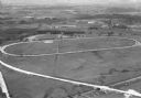
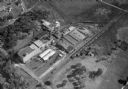
| Description: | Aerial view of the Dane County fairgrounds, including several buildings and a track. |
| Date: | 1930 |
|---|---|
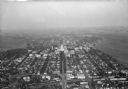
| Description: | Aerial view looking southeast, towards the city, including the Wisconsin State Capitol, the central business district, the Capitol Square, both Lake Mendot... |
| Date: | |
|---|---|
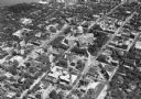
| Description: | Aerial view of downtown area featuring the Wisconsin State Capitol. |

| Date: | 1930 |
|---|---|
| Description: | Aerial view of the University of Wisconsin-Madison campus, the State Historical Society of Wisconsin building, Lake Mendota, residential areas and the surr... |
| Date: | 1930 |
|---|---|
| Description: | Aerial view of the city and the Isthmus, the Wisconsin State Capitol, the downtown business district, and both Lake Mendota and Lake Monona. |
| Date: | 1930 |
|---|---|
| Description: | Aerial view of the city, including the Isthmus, the Wisconsin State Capitol, the downtown business district, Lake Mendota, and Lake Monona. |

| Date: | 1930 |
|---|---|
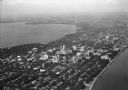
| Description: | Aerial view of the Wisconsin State Capitol, the surrounding businesses, and Lake Monona. |

| Date: | 1930 |
|---|---|
| Description: | Aerial view of the Wisconsin State Capitol and the surrounding businesses. |

| Date: | 1930 |
|---|---|
| Description: | Aerial view of the Wisconsin State Capitol and the surrounding businesses. |

| Date: | 1930 |
|---|---|
| Description: | Aerial view of the city with horizon in the far distance. Includes the Wisconsin State Capitol, businesses, Lake Monona, and the surrounding neighborhoods. |

| Date: | 1930 |
|---|---|
| Description: | Aerial view of the University of Wisconsin-Madison campus including Camp Randall Stadium, the Wisconsin State Capitol, and both Lake Mendota and Lake Monon... |

| Date: | 1930 |
|---|---|
| Description: | Aerial view of near west side, including West High School, the Forest Products Laboratory, Lake Mendota, and Picnic Point. |
| Date: | 1932 |
|---|---|
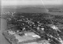
| Description: | Aerial view of the Oscar Mayer Meat Packing Plant and the surrounding neighborhoods on the east side. |
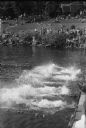
| Date: | 08 06 1944 |
|---|---|
| Description: | Annual city municipal swimming meet at B.B. Clarke Beach, with swimmers in the water, and observers along the shore, with cars, and houses in the neighborh... |

| Date: | 01 19 1945 |
|---|---|
| Description: | Edgewood fence along Wingra Drive entrance which had been opened to the public after closing by the Dominican Sisters of Edgewood Academy. |
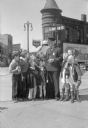
| Date: | 04 12 1945 |
|---|---|
| Description: | Officer Frank B. Ingraham, at his beat on the corners of State, Henry, and Johnson Streets, with young school children from Holy Redeemer School. Ingraham ... |

| Date: | 05 17 1945 |
|---|---|
| Description: | 100 block of East Doty Street, showing the Fess Hotel, 119-123; Municipal Parking Station, 115; Kentzler building, 109; and Endres Tiedeman Mobil gas stati... |

| Date: | 06 14 1945 |
|---|---|
| Description: | Henry Johnson house, 304 West Washington Avenue, built in 1856 by Neely Gray. |
If you didn't find the material you searched for, our Library Reference Staff can help.
Call our reference desk at 608-264-6535 or email us at: