 Filter: Categories of Wisconsin Historical Images
Filter: Subject of Land use, Rural
Filter: Year of 1900-1999
Filter: Categories of Wisconsin Historical Images
Filter: Subject of Land use, Rural
Filter: Year of 1900-1999
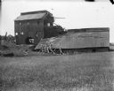
| Date: | 1909 |
|---|---|
| Description: | A deteriorating mining building seen from across a field. |

| Date: | 1957 |
|---|---|
| Description: | Aerial view of Yellowstone Lake and surrounding countryside. |
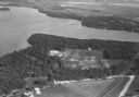
| Date: | 1930 |
|---|---|
| Description: | Aerial view of Turville Point and Turville farm, Lake Monona. |

| Date: | 11 1928 |
|---|---|
| Description: | Aerial view of Verona including businesses, houses, and the surrounding farm land. |

| Date: | 10 1928 |
|---|---|
| Description: | Aerial view of Sun Prairie, including the central business district, residences, and the surrounding countryside stretching to the horizon. |
| Date: | 1934 |
|---|---|
| Description: | Aerial view of the Jones dairy farm, Fort Atkinson, in winter. The Rock River is in the background. |

| Date: | 11 1928 |
|---|---|
| Description: | Aerial view of Stoughton, including the central business district, residential areas, the Yahara River, and the surrounding countryside. |

| Date: | 11 1928 |
|---|---|
| Description: | Aerial view residential areas of Windsor and the surrounding countryside. |

| Date: | 11 1928 |
|---|---|
| Description: | Aerial view of Black Earth residential area and the surrounding countryside. |

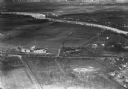
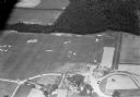
| Date: | 1930 |
|---|---|
| Description: | Aerial view of the town and the surrounding countryside. |

| Date: | 11 1928 |
|---|---|
| Description: | Aerial view of Cross Plains, including residences and the surrounding countryside. |
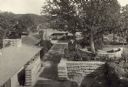
| Date: | 1912 |
|---|---|
| Description: | Taliesin I courtyard looking southeast toward living room wing from the hayloft. |
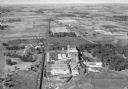
| Date: | 1932 |
|---|---|
| Description: | Aerial view of the Oscar Mayer meat packing plant, looking north, with the surrounding rural countryside. |
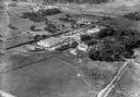
| Date: | 1932 |
|---|---|
| Description: | Aerial view of Oscar Mayer Meat Packing Plant and the surrounding countryside. |

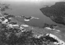
| Date: | 1930 |
|---|---|
| Description: | Aerial view of Wisconsin Dells including the Wisconsin River and the dam and generating power plant. |
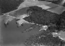
| Date: | 1930 |
|---|---|
| Description: | Aerial view of Lake Delton, the Wisconsin River, and the surrounding countryside. |
| Date: | 1930 |
|---|---|
| Description: | Aerial view of Lake Delton and shoreline including resort areas. |
| Date: | 1930 |
|---|---|
| Description: | Aerial view of the Lake Delview Hotel, the golf course, and the surrounding countryside. |

| Date: | 1930 |
|---|---|
| Description: | Aerial view of Pennco Field (Royal Airport), and Lake Monona near the city limits. A crowd is gathered at the airport to watch an air show. |
If you didn't find the material you searched for, our Library Reference Staff can help.
Call our reference desk at 608-264-6535 or email us at:
