Filter: Categories of Wisconsin Historical Images
Filter: Subject of Land use, Rural
Filter: Year of 1900-1999
Filter: Year of 1920-1929
Filter: Categories of Wisconsin Historical Images
Filter: Subject of Land use, Rural
Filter: Year of 1900-1999
Filter: Year of 1920-1929
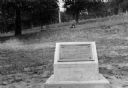
| Date: | 1925 |
|---|---|
| Description: | View of a marker commemorating Old Helena. |

| Date: | 11 1928 |
|---|---|
| Description: | Aerial view of Verona including businesses, houses, and the surrounding farm land. |

| Date: | 10 1928 |
|---|---|
| Description: | Aerial view of Sun Prairie, including the central business district, residences, and the surrounding countryside stretching to the horizon. |

| Date: | 11 1928 |
|---|---|
| Description: | Aerial view of Stoughton, including the central business district, residential areas, the Yahara River, and the surrounding countryside. |

| Date: | 11 1928 |
|---|---|
| Description: | Aerial view residential areas of Windsor and the surrounding countryside. |

| Date: | 11 1928 |
|---|---|
| Description: | Aerial view of Black Earth residential area and the surrounding countryside. |

| Date: | 11 1928 |
|---|---|
| Description: | Aerial view of Cross Plains, including residences and the surrounding countryside. |
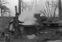
| Date: | 1927 |
|---|---|
| Description: | Man in "sugar bush" (grove of maples) boiling down maple sap in production of maple syrup. Probably Wisconsin. |
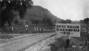
| Date: | 1927 |
|---|---|
| Description: | View of the Battle Hollow sign along an unpaved road. In the distance on the left is a rock formation covered with trees. Sign reads: "Battle Hollow Clack ... |

| Date: | 1928 |
|---|---|
| Description: | T. N19 R. 4W about section 19, McPeak farm. A 50 foot deep ravine is seen rapidly eating its way toward farm buildings. |
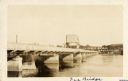
| Date: | 1925 |
|---|---|
| Description: | View across water along the right side of the Sauk City bridge, erected in 1922 to replace an old toll bridge. tree-covered hills are on the opposite shore... |
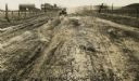
| Date: | 1926 |
|---|---|
| Description: | Car on a dirt highway west of Hustler. The highway is U.S. 12 and 16. |
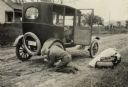
| Date: | 1923 |
|---|---|
| Description: | Tire blowouts were a frequent hazard of early automobile travel. |
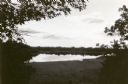
| Date: | 1923 |
|---|---|
| Description: | View of Fountain Lake (officially known as Ennis Lake), John Muir's boyhood home near Montello. The area is now a 125-acre State Natural Area. Fountain Lak... |
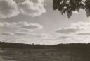
| Date: | 1923 |
|---|---|
| Description: | View of Fountain Lake (officially known as Ennis Lake), John Muir's boyhood home near Montello. The area is now a 125-acre State Natural Area. Fountain Lak... |
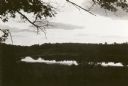
| Date: | 1923 |
|---|---|
| Description: | View of Fountain Lake (officially known as Ennis Lake), John Muir's boyhood home near Montello. The area is now a 125-acre State Natural Area. Fountain Lak... |

| Date: | 06 29 1928 |
|---|---|
| Description: | Several people harvest grain by hand, while two men on horses look on. All the men wear sombreros; the men on horses wear suits, while the harvesters wear... |
If you didn't find the material you searched for, our Library Reference Staff can help.
Call our reference desk at 608-264-6535 or email us at: