Filter: Categories of Wisconsin Historical Images
Filter: Subject of Land use, Rural
Filter: Year of 1900-1999
Filter: County of Dane
Filter: Categories of Wisconsin Historical Images
Filter: Subject of Land use, Rural
Filter: Year of 1900-1999
Filter: County of Dane
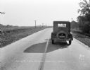
| Date: | 10 20 1931 |
|---|---|
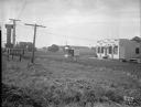
| Description: | View looking down road (east-south east) towards the rear of a car parked in the right lane of a two lane highway. This was the scene of an accident, and i... |
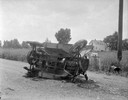
| Date: | 10 20 1931 |
|---|---|
| Description: | Accident scene on Highway 51, rural area. Caption at bottom reads: "High #51 — Looking West — Northwest — October 20, 1931 2:00 P.M." |
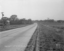
| Date: | 08 10 1931 |
|---|---|
| Description: | County Highway G, Mount Vernon, looking south, taken for Travelers Insurance Co. Dane County. |
| Date: | 06 30 1931 |
|---|---|
| Description: | Ray's Barbecue and Standard Oil Gas Station, on the Oregon Road (just beyond the French Village which was located at 2323 S. Park Street). |
| Date: | 05 25 1931 |
|---|---|
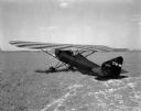
| Description: | Three-quarter view from left rear towards the "Keen-Ship" airplane parked on a field, with Charles F. Keen, pilot. |
| Date: | 05 23 1931 |
|---|---|
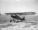
| Description: | Three-quarter view from front left towards an airplane parked in a field, "The Keen Ship," made by Charles F. Keen. |
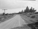
| Date: | 11 08 1928 |
|---|---|
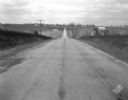
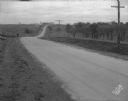
| Description: | Stretch of paved rural highway featuring a proprietary centerline joint, looking towards Mount Horeb from the east. |
| Date: | 11 08 1928 |
|---|---|
| Description: | Stretch of paved rural highway near Mount Horeb featuring a proprietary centerline joint. |
| Date: | 1913 |
|---|---|
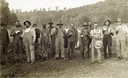
| Description: | Group of farm workers, men and women, posing in a field, holding various beverages. One man has his arm over a barrel on a stand in the center. In the back... |
| Date: | 1915 |
|---|---|
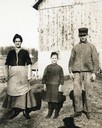
| Description: | Photographic postcard of a farm couple and their daughter posing outdoors in front of a barn. |
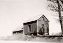
| Date: | 06 1925 |
|---|---|
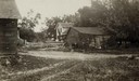
| Description: | View of three farm buildings - the one in the center is collapsing. |
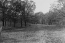
| Date: | 1930 |
|---|---|
| Description: | View of a wide path through trees in the spring or summer. |

| Date: | 1930 |
|---|---|
| Description: | Remains of the racetrack on the top of Blue Mound. |
| Date: | 1928 |
|---|---|
| Description: | View from hill of uptown Cross Plains with the Catholic Church (St. Francis Xavier) and farmhouses. |

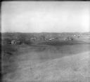
| Date: | 1955 |
|---|---|
| Description: | Aerial view of Cross Plains, with countryside surrounding and hills on the horizon. |
| Date: | 1976 |
|---|---|
| Description: | Niels-Larsen granary on its original site, before its removal to Old World Wisconsin, Eagle, Wis;, where it was erected on the Norwegian site. |

| Date: | 1956 |
|---|---|
| Description: | Aerial view of the new Madison television facility, WISC-TV (Channel 3), showing the transmitting tower in construction. The location is to the southwest,... |
If you didn't find the material you searched for, our Library Reference Staff can help.
Call our reference desk at 608-264-6535 or email us at: