 Filter: Categories of Wisconsin Historical Images
Filter: Subject of Land use, Rural
Filter: Year of 1700-1799
Filter: Year of 1790-1799
Filter: Categories of Wisconsin Historical Images
Filter: Subject of Land use, Rural
Filter: Year of 1700-1799
Filter: Year of 1790-1799

| Date: | 1790 |
|---|---|
| Description: | This map of the north eastern states shows roads, rivers, lakes, waterfalls, mountains, cities, forts, mills, the Oneida Reservation, and "New York Donatio... |

| Date: | 1790 |
|---|---|
| Description: | An ink and hand-colored map, showing the land and landowners of the Susquehanna company purchase in Pennsylvania. Rivers are shown and occasionally labeled... |
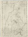
| Date: | 1791 |
|---|---|
| Description: | Detailed map of New Hampshire. It shows counties, cities, mountains, highlands, lakes, and rivers. The acres given to Dartmouth College are labeled far in ... |

| Date: | 1792 |
|---|---|
| Description: | Map of Pennsylvania showing counties, cities, towns, forges and mills, houses, roads, portages, mountains, lakes, and rivers. The map also shows donation a... |

| Date: | 1793 |
|---|---|
| Description: | Detailed topographical map of the Ohio River between Clarkville and Louisville. It shows plots of farmland, forest, islands, garden plots, houses, Fort Fe... |
If you didn't find the material you searched for, our Library Reference Staff can help.
Call our reference desk at 608-264-6535 or email us at: