 Filter: Categories of Wisconsin Historical Images
Filter: Subject of Land use, Rural
Filter: Subject of wetlands
Filter: Categories of Wisconsin Historical Images
Filter: Subject of Land use, Rural
Filter: Subject of wetlands
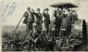
| Date: | 09 08 1914 |
|---|---|
| Description: | Five men in hats and jackets, some holding the levers on a gang plow pulled by a Rumley tractor, pose for a group portrait. One man in work clothes stands ... |

| Date: | 1914 |
|---|---|
| Description: | View of a drainage ditch in Horicon Marsh. A man is on a path along the left of the ditch. |
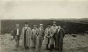
| Date: | 1914 |
|---|---|
| Description: | Group of well-dressed men standing in front of a plowed segment of Horicon Marsh. |

| Date: | 10 1914 |
|---|---|
| Description: | View of furrowed ground in Horicon Marsh and men on a tractor in the process of plowing a drained portion of the marsh. |
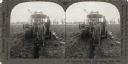
| Date: | |
|---|---|
| Description: | Stereograph showing workers digging a ditch with a tractor and laying drain tile. |

| Date: | 1840 |
|---|---|
| Description: | This map shows a line of proposed construction for defending the north side of the canal against inundation from the Wisconsin River and location of Fort W... |

| Date: | 1973 |
|---|---|
| Description: | This map shows the uses of land in St. Croix County. Uses are indicated by colored dots. Residential(Yellow), Commercial(Red), Industrial(Grey), Parks and ... |

| Date: | 1970 |
|---|---|
| Description: | This map shows colored-coded land use with a legend in the bottom margin. Land classifications include: Year-round Residential (yellow), Seasonal Residenti... |

| Date: | 1973 |
|---|---|
| Description: | This map is 1 of 7 and includes a location map and township diagram in the margins. The map includes a key of land type: Residential (yellow), Commercial (... |

| Date: | 1973 |
|---|---|
| Description: | This map is 2 of 7 and includes a location map and township diagram in the bottom margin. The map includes a key of land type: Residential (yellow), Commer... |

| Date: | 1973 |
|---|---|
| Description: | This map is 3 of 7 and includes a location map and township diagram in the margins. The map includes a key of land type: Residential (yellow), Commercial (... |

| Date: | 1973 |
|---|---|
| Description: | This map is 4 of 7 and includes a location map and township diagram in the left margin. The map includes a key of land type: Residential (yellow), Commerci... |

| Date: | 1973 |
|---|---|
| Description: | This map is 5 of 7 and includes a location map and township diagram in the left margin. The map includes a key of land type: Residential (yellow), Commerci... |

| Date: | 1973 |
|---|---|
| Description: | This map is 6 of 7 and includes a location map and township diagram in the bottom margin. The map includes a key of land type: Residential (yellow), Commer... |

| Date: | 1973 |
|---|---|
| Description: | This map is 7 of 7 and includes a location map and township diagram in the left margin. The map includes a key of land type: Residential (yellow), Commerci... |
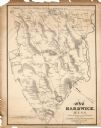
| Date: | 1833 |
|---|---|
| Description: | The map shows the distance of each dwelling-house from the common. The dwellings are listed by name of owner. |
If you didn't find the material you searched for, our Library Reference Staff can help.
Call our reference desk at 608-264-6535 or email us at:
