 Filter: Categories of Wisconsin Historical Images
Filter: Subject of Land use, Rural
Filter: Subject of botany
Filter: Subject of public utilities
Filter: Categories of Wisconsin Historical Images
Filter: Subject of Land use, Rural
Filter: Subject of botany
Filter: Subject of public utilities

| Date: | 02 24 1978 |
|---|---|
| Description: | "Theresa Waste Disposal System. Village man, Jim Zillmer, checks out sprinkler system." |
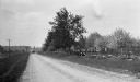
| Date: | 1916 |
|---|---|
| Description: | A cow, lying outside the fence, observes a car stopped on Sturgeon Bay Road (now Highway 42). Cherry trees bloom inside the fence. |

| Date: | |
|---|---|
| Description: | View across open area towards a brick power plant, where a man and a small dog are standing. Cords of wood are stacked at the left side of the building. On... |

| Date: | 1973 |
|---|---|
| Description: | This map is 1 of 7 and includes a location map and township diagram in the margins. The map includes a key of land type: Residential (yellow), Commercial (... |

| Date: | 1973 |
|---|---|
| Description: | This map is 2 of 7 and includes a location map and township diagram in the bottom margin. The map includes a key of land type: Residential (yellow), Commer... |

| Date: | 1973 |
|---|---|
| Description: | This map is 3 of 7 and includes a location map and township diagram in the margins. The map includes a key of land type: Residential (yellow), Commercial (... |

| Date: | 1973 |
|---|---|
| Description: | This map is 4 of 7 and includes a location map and township diagram in the left margin. The map includes a key of land type: Residential (yellow), Commerci... |

| Date: | 1973 |
|---|---|
| Description: | This map is 5 of 7 and includes a location map and township diagram in the left margin. The map includes a key of land type: Residential (yellow), Commerci... |

| Date: | 1973 |
|---|---|
| Description: | This map is 6 of 7 and includes a location map and township diagram in the bottom margin. The map includes a key of land type: Residential (yellow), Commer... |

| Date: | 1973 |
|---|---|
| Description: | This map is 7 of 7 and includes a location map and township diagram in the left margin. The map includes a key of land type: Residential (yellow), Commerci... |
If you didn't find the material you searched for, our Library Reference Staff can help.
Call our reference desk at 608-264-6535 or email us at: