Filter: Categories of Wisconsin Historical Images
Filter: Subject of Land use, Rural
Filter: Subject of botany
Filter: Type of Photograph
Filter: Categories of Wisconsin Historical Images
Filter: Subject of Land use, Rural
Filter: Subject of botany
Filter: Type of Photograph

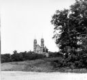
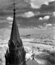
| Date: | 1909 |
|---|---|
| Description: | Exterior view of the Harrisburg Church. There are long hills in the background. |
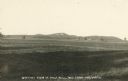
| Date: | |
|---|---|
| Description: | View of Holy Hill. Caption reads: "Distant View of Holy Hill, Wis from the South". |
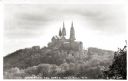
| Date: | 1920 |
|---|---|
| Description: | View of the Carmelite monastery on Holy Hill from the north. Caption reads: "View from the North, Holy Hill, Wis." |
| Date: | 1950 |
|---|---|
| Description: | View looking up hill towards the Holy Hill monastery and church. |
| Date: | 1963 |
|---|---|
| Description: | Elevated view of the Kettle Moraine area from Holy Hill. |
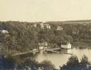
| Date: | 1907 |
|---|---|
| Description: | Elevated view of the Che-ne-qua Hotel on Pine Lake. |
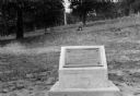
| Date: | 1925 |
|---|---|
| Description: | View of a marker commemorating Old Helena. |
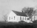
| Date: | 1950 |
|---|---|
| Description: | View of the Little Prairie school with a car parked alongside it. Playground equipment is in the yard. |
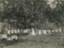
| Date: | |
|---|---|
| Description: | A family, man, woman and infant, sitting under a tree in a bee apiary. Behind them are rows of hives. |
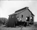
| Date: | 1910 |
|---|---|
| Description: | An old, dilapidated mining building surrounded by a field. |

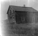
| Date: | 1957 |
|---|---|
| Description: | Aerial view of Yellowstone Lake and surrounding countryside. |

| Date: | 11 1928 |
|---|---|
| Description: | Aerial view of Verona including businesses, houses, and the surrounding farm land. |

| Date: | 10 1928 |
|---|---|
| Description: | Aerial view of Sun Prairie, including the central business district, residences, and the surrounding countryside stretching to the horizon. |

| Date: | 11 1928 |
|---|---|
| Description: | Aerial view of Stoughton, including the central business district, residential areas, the Yahara River, and the surrounding countryside. |

| Date: | 11 1928 |
|---|---|
| Description: | Aerial view residential areas of Windsor and the surrounding countryside. |

| Date: | 11 1928 |
|---|---|
| Description: | Aerial view of Black Earth residential area and the surrounding countryside. |

| Date: | 11 1928 |
|---|---|
| Description: | Aerial view of Cross Plains, including residences and the surrounding countryside. |
| Date: | 1912 |
|---|---|
| Description: | Taliesin I courtyard looking southeast toward living room wing from the hayloft. |
If you didn't find the material you searched for, our Library Reference Staff can help.
Call our reference desk at 608-264-6535 or email us at: