 Filter: Categories of Wisconsin Historical Images
Filter: Subject of Land use, Rural
Filter: County of Waukesha
Filter: Categories of Wisconsin Historical Images
Filter: Subject of Land use, Rural
Filter: County of Waukesha
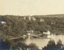
| Date: | 1907 |
|---|---|
| Description: | Elevated view of the Che-ne-qua Hotel on Pine Lake. |

| Date: | 08 23 1917 |
|---|---|
| Description: | Man, possibly Joseph Brown, attending to an automobile on the road between Waukesha and Ionsman. Rural landscape and farm in the background. |
| Date: | 1937 |
|---|---|
| Description: | Exterior view of a two-story house with several trees on the farm of Fred Esser. On the right is a barn with two silos. On the far left in a fenced area on... |

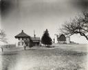
| Date: | 1926 |
|---|---|
| Description: | A view of the front of large house with an open front porch, a front yard with mature trees, and a field beyond. The house features six over six window sas... |

| Date: | 1926 |
|---|---|
| Description: | A side view from road of large brick house with an open front porch, surrounded by trees. There is a a rear wing and attached garage or shed. |
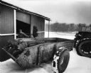
| Date: | 12 11 1983 |
|---|---|
| Description: | Delmer Staus of Waukesha County shoveling contents of one of his cow barns into a manure spreader. |
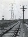
| Date: | 03 1928 |
|---|---|
| Description: | Power lines along both sides of railroad tracks running through a rural area. |
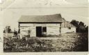
| Date: | |
|---|---|
| Description: | Exterior view of the Bache farm. In the foreground is a small building with an open door. In the background is a large barn with stone foundation and a lar... |
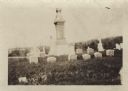
| Date: | |
|---|---|
| Description: | Ten graves of the Hedjord family in the Muskego churchyard. There is an obelisk is the center of graves. |
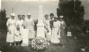
| Date: | |
|---|---|
| Description: | Outdoor group portrait of women and one child alongside the graves of Colonel Hans Heg, commander of the 15th Wisconsin Infantry, and his daughter Annetta.... |
| Date: | |
|---|---|
| Description: | Alfred Lunt driving a tractor pulling Ben Perkins in a cart. Mr. Perkins is likely seeding the furrows. |

| Date: | 1934 |
|---|---|
| Description: | This map shows the area as it appeared in 1848 and includes buildings, land use, and roads with distances to nearby locations. The upper right corner reads... |

| Date: | |
|---|---|
| Description: | A man is posing in a horse-drawn buggy on the drive in front of a tree-lined fence. Caption on slide reads: "Farm elm near Waukesha, Wis." Hand-tinted lant... |

| Date: | |
|---|---|
| Description: | View down a long dirt road. In the distance the road passes under a railroad bridge near a church with a cemetery. Caption reads: "Lover's Lane, Mapleton, ... |
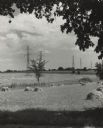
| Date: | 1956 |
|---|---|
| Description: | A line of high-voltage towers march across fields of oats and barley into the distance. |

| Date: | 07 1976 |
|---|---|
| Description: | Rear view of a group of tourists at Old World Wisconsin viewing a barn and other farm buildings. |
If you didn't find the material you searched for, our Library Reference Staff can help.
Call our reference desk at 608-264-6535 or email us at: