 Filter: Categories of Wisconsin Historical Images
Filter: Subject of Land use, Rural
Filter: County of Monroe
Filter: Categories of Wisconsin Historical Images
Filter: Subject of Land use, Rural
Filter: County of Monroe

| Date: | 05 31 1965 |
|---|---|
| Description: | Elevated view of Evangelical United Brethren church in the vicinity of Highway T. |

| Date: | 1928 |
|---|---|
| Description: | T. N19 R. 4W about section 19, McPeak farm. A 50 foot deep ravine is seen rapidly eating its way toward farm buildings. |
| Date: | 1880 |
|---|---|
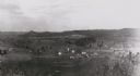
| Description: | Elevated view from hill towards farm fields and houses. Tree-covered hills are in the distance. |
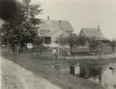
| Date: | 1900 |
|---|---|
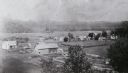
| Description: | Elevated view from hill towards farm fields and houses in Oil City. Tree-covered hills are in the distance. |
| Date: | 10 08 1997 |
|---|---|
| Description: | Group of men harvesting cranberries. |
| Date: | 07 20 1929 |
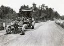
|---|---|
| Description: | Emil Anderson operates a road grader marked "Russell Motor Patrol No.3" on Highway 12. |
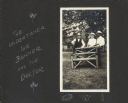
| Date: | 1911 |
|---|---|
| Description: | A portrait of Frank King's neighbors posed around a bench outdoors on Flora Dell Lake. From left to right, an unidentified man is described as an undertake... |

| Date: | 05 31 1965 |
|---|---|
| Description: | Exterior view of a farm with a round barn. A truck and farmhouse is behind and to the left in a grove of trees. |
| Date: | 09 09 1922 |
|---|---|
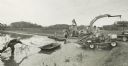
| Description: | The farmhouse of the Wetherby Cranberry Company. At the time the farmhouse was owned by H. Kissinger. In the foreground is the corner of the water reservoi... |
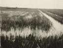
| Date: | 07 24 1922 |
|---|---|
| Description: | A weed killing flood at Robert Rezin's Cranberry Marsh. |
| Date: | 1997 |
|---|---|
| Description: | Harvesters wade through cranberries contained by booms in the cranberry marsh as they travel on a conveyor belt into the waiting trucks. |
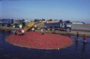
| Date: | 1997 |
|---|---|
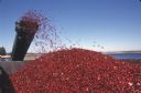
| Description: | Cranberries fly off of a conveyor belt onto a large pile in the back of a truck during harvest. |
| Date: | 1997 |
|---|---|
| Description: | Men positioning floating booms to confine the cranberries so they can be harvested. |
| Date: | 1997 |
|---|---|
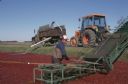
| Description: | A man stands in the water next to the conveyor belt that transports cranberries into the truck. |
| Date: | 1997 |
|---|---|
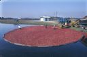
| Description: | Elevated view of harvesters wading through cranberries contained by booms to feed them onto a conveyor to be loaded into the waiting trucks. |
| Date: | 1997 |
|---|---|
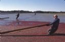
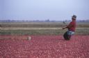
| Description: | A man wearing waders walks knee-deep through water and floating cranberries as he pulls a boom used for confining the cranberries so they can be harvested. |

| Date: | 1909 |
|---|---|
| Description: | This is one of a set of two topographical maps showing land use, roads, railroads, bridges, and buildings with ownership in parts of LaFayette, Greenfield,... |

| Date: | 1909 |
|---|---|
| Description: | This the second of a set of two topographical maps showing land use, roads, railroads, bridges, and buildings with ownership in parts of LaFayette, Greenfi... |

| Date: | 05 26 1947 |
|---|---|
| Description: | View across road and fields towards three wooded hill peaks. A roadside fence is in the foreground. Caption reads: "D.A. 36-268 — Three peaks on Hy.71 betw... |

| Date: | 1975 |
|---|---|
| Description: | View across water towards a rooster perching in a barn window, looking over his domain. |
If you didn't find the material you searched for, our Library Reference Staff can help.
Call our reference desk at 608-264-6535 or email us at: