 Filter: Categories of Wisconsin Historical Images
Filter: Subject of Land use, Rural
Filter: County of Juneau
Filter: Year of 1900-1999
Filter: Categories of Wisconsin Historical Images
Filter: Subject of Land use, Rural
Filter: County of Juneau
Filter: Year of 1900-1999
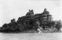
| Date: | 1937 |
|---|---|
| Description: | Castle Rock. Castle Rock is an example of a monadnock or inselberg, a geological formation common in northern and central Wisconsin. |
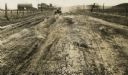
| Date: | 1926 |
|---|---|
| Description: | Car on a dirt highway west of Hustler. The highway is U.S. 12 and 16. |
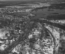
| Date: | 04 16 1949 |
|---|---|
| Description: | Aerial view of Necedah, Wisconsin, and Petenwell Lake behind Petenwell Dam on the Wisconsin River. |
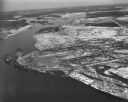
| Date: | 04 16 1949 |
|---|---|
| Description: | Aerial view of Castle Rock Dam on the Wisconsin River near Mauston, Wisconsin. |

| Date: | 1935 |
|---|---|
| Description: | Map of Juneau County showing area zoned for reforestation shaded in red. |
| Date: | 1935 |
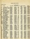
|---|---|
| Description: | List of Juneau County landowners and details of the sale of their land to the United States Resettlement Administration. |
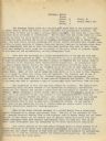
| Date: | 1935 |
|---|---|
| Description: | Page 1 of textual description of Brundage family and their resettlement from poor farmland to land better suited to agriculture. |
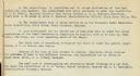
| Date: | 1935 |
|---|---|
| Description: | Page 2 of textual description of Brundage family and their resettlement from poor farmland to land better suited to agriculture. |
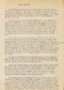
| Date: | 1935 |
|---|---|
| Description: | Page 1 of a description of the resettlement of Walter Brundage from poor farmland owned by Dr. Roach to land better suited to agriculture owned by Pat Glea... |
| Date: | 1935 |
|---|---|
| Description: | Page 2 of a description of the resettlement of Walter Brundage from poor farmland owned by Dr. Roach to land better suited to agriculture owned by Pat Glea... |
| Date: | 1935 |
|---|---|
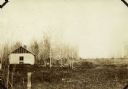
| Description: | View of the dilapidated farm from which the Brundage family moved with the assistance of The United States Resettlement Administration. |

| Date: | 1935 |
|---|---|
| Description: | View of the farm to which the Brundage family moved with the assistance of The United States Resettlement Administration. |

| Date: | 07 1900 |
|---|---|
| Description: | View across field of a deserted cabin at Camp Douglas. Another group of cabins are behind a fence on the right. Trees and foliage are in the background. |

| Date: | 10 20 1978 |
|---|---|
| Description: | View across field towards a wagon stacked with bales of hay near a barn and a silo at the base of a bluff near Union Center. |
If you didn't find the material you searched for, our Library Reference Staff can help.
Call our reference desk at 608-264-6535 or email us at: