Filter: Categories of Wisconsin Historical Images
Filter: Subject of Land use, Rural
Filter: County of Juneau
Filter: Categories of Wisconsin Historical Images
Filter: Subject of Land use, Rural
Filter: County of Juneau
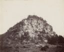
| Date: | 1937 |
|---|---|
| Description: | Castle Rock. Castle Rock is an example of a monadnock or inselberg, a geological formation common in northern and central Wisconsin. |
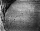
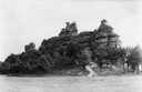
| Date: | |
|---|---|
| Description: | Thunderbird petroglyphs carved on rock face at Twin Bluffs. |
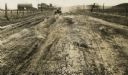
| Date: | 1926 |
|---|---|
| Description: | Car on a dirt highway west of Hustler. The highway is U.S. 12 and 16. |
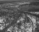
| Date: | 04 16 1949 |
|---|---|
| Description: | Aerial view of Necedah, Wisconsin, and Petenwell Lake behind Petenwell Dam on the Wisconsin River. |
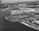
| Date: | 04 16 1949 |
|---|---|
| Description: | Aerial view of Castle Rock Dam on the Wisconsin River near Mauston, Wisconsin. |
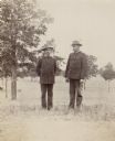
| Date: | |
|---|---|
| Description: | Two military officers, Major Mahoney and H. Schildhauer stand, in a field with small saplings. |
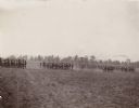
| Date: | |
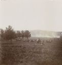
|---|---|
| Description: | Formations of soldiers at Camp Douglas march across a large parade field. A line of trees are in the distance, and a building with a chimney is visible abo... |
| Date: | |
|---|---|
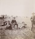
| Description: | Soldiers resting on the grass at Camp Douglas. In the background are tents pitched among trees. |
| Date: | 1894 |
|---|---|
| Description: | View down hill of the 3rd Regiment enacting a mock battle in an open, rural area. |
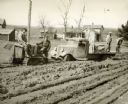
| Date: | |
|---|---|
| Description: | A man with a tractor attempts to pull a truck out of deep mud. Two men stand on the bed of the truck, and another man sits on the front of the tractor. The... |

| Date: | 1935 |
|---|---|
| Description: | Map of Juneau County showing area zoned for reforestation shaded in red. |
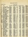
| Date: | 1935 |
|---|---|
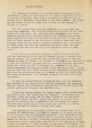
| Description: | List of Juneau County landowners and details of the sale of their land to the United States Resettlement Administration. |
| Date: | 1935 |
|---|---|
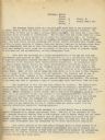
| Description: | Page 1 of textual description of Brundage family and their resettlement from poor farmland to land better suited to agriculture. |
| Date: | 1935 |
|---|---|
| Description: | Page 2 of textual description of Brundage family and their resettlement from poor farmland to land better suited to agriculture. |
| Date: | 1935 |
|---|---|
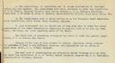
| Description: | Page 1 of a description of the resettlement of Walter Brundage from poor farmland owned by Dr. Roach to land better suited to agriculture owned by Pat Glea... |
| Date: | 1935 |
|---|---|
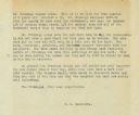
| Description: | Page 2 of a description of the resettlement of Walter Brundage from poor farmland owned by Dr. Roach to land better suited to agriculture owned by Pat Glea... |
| Date: | 1935 |
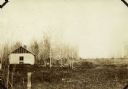
|---|---|
| Description: | View of the dilapidated farm from which the Brundage family moved with the assistance of The United States Resettlement Administration. |

| Date: | 1935 |
|---|---|
| Description: | View of the farm to which the Brundage family moved with the assistance of The United States Resettlement Administration. |

| Date: | |
|---|---|
| Description: | Group of men posing in two rows in a field. The men sitting and crouching in the front row are wearing folded down rubber boots. The men standing behind th... |
If you didn't find the material you searched for, our Library Reference Staff can help.
Call our reference desk at 608-264-6535 or email us at: