Filter: Categories of Wisconsin Historical Images
Filter: Subject of Land use, Rural
Filter: County of Door
Filter: Subject of transportation
Filter: Categories of Wisconsin Historical Images
Filter: Subject of Land use, Rural
Filter: County of Door
Filter: Subject of transportation
| Date: | 1905 |
|---|---|
| Description: | A lane in Ephraim with power lines lining the road. There is a body of water in the distance with houses on the far shoreline. |
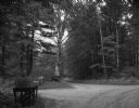
| Date: | 08 23 1964 |
|---|---|
| Description: | A road intersection, surrounded by woods. Four mailboxes and several road signs are visible. |
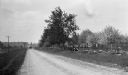
| Date: | 1916 |
|---|---|
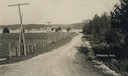
| Description: | A cow, lying outside the fence, observes a car stopped on Sturgeon Bay Road (now Highway 42). Cherry trees bloom inside the fence. |
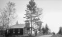
| Date: | 1925 |
|---|---|
| Description: | Three women pose on the steps of the Baptist Church at Ellison Bay, which has an open bell tower. A car is parked a short distance down the dirt road. |

| Date: | 1922 |
|---|---|
| Description: | View from hill of cherry trees in bloom in the Gibraltar Orchard on Sturgeon Bay Road (Highway 42.) |

| Date: | 1943 |
|---|---|
| Description: | This 1943 map of Door County, Wisconsin, identifies the post offices and rural routes in the county. Highways and roads, cities and villages, and rural res... |
If you didn't find the material you searched for, our Library Reference Staff can help.
Call our reference desk at 608-264-6535 or email us at: