Filter: Categories of Wisconsin Historical Images
Filter: Subject of Land
Filter: Categories of Wisconsin Historical Images
Filter: Subject of Land
| Date: | 1832 |
|---|---|
| Description: | Engraving of Indians on horseback along river with Indian grave on hill in background. |

| Date: | 1832 |
|---|---|
| Description: | Black and white engraving showing landscape with Fort Pierre and Indian tipis along the Missouri River. |
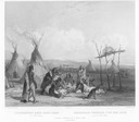
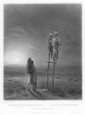
| Date: | 1832 |
|---|---|
| Description: | Funeral of a Sioux Chief near Fort Pierre. |
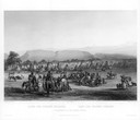
| Date: | 1832 |
|---|---|
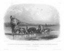
| Description: | Punka Indians encamped on the banks of the Missouri River and canoeing in river. |
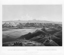
| Date: | 1832 |
|---|---|
| Description: | Mih-Tutta-Hangkusch, a Mandan village with boats on the river in foreground. |
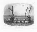
| Date: | 1832 |
|---|---|
| Description: | Offering of the Mandan Indians, showing human and animal skulls. |
| Date: | 1832 |
|---|---|
| Description: | Two dog-sledges hauling supplies, with one also carrying a Mandan. |

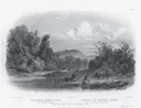
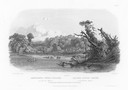
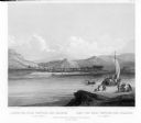
| Date: | 1832 |
|---|---|
| Description: | Junction of the Yellowstone River and the Missouri River. |

| Date: | 05 20 1930 |
|---|---|
| Description: | The Montgomery Ward Store Building at 100 North Hamilton Street, at the intersection of Pinckney and North Hamilton Streets. The building was designed by L... |
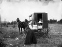
| Date: | 1890 |
|---|---|
| Description: | A woman, possibly the daughter of C.R. Monroe, holding up an image of Black River Falls Main Street at the back of a traveling photographer's wagon. |
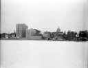
| Date: | 12 18 1955 |
|---|---|
| Description: | Downtown Madison lakeshore taken from Lake Monona in line with South Pinckney Street. Includes St. Raphael's steeple, 1 West Wilson Street state office bui... |

| Date: | 1886 |
|---|---|
| Description: | Bird's-eye view of Bayfield, county seat of Bayfield County. On the lower left side is an inset for Bayfield and the Apostle Islands. |

| Date: | 07 10 1949 |
|---|---|
| Description: | Aerial view of Minocqua showing the surrounding lakes. |
| Date: | 1832 |
|---|---|
| Description: | Camp of the Gros Ventres along the upper Missouri River, with white travelers passing by in a boat. |
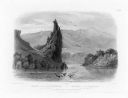
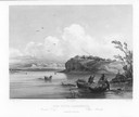
| Date: | 1832 |
|---|---|
| Description: | The Citadel Rock on the Upper Missouri River. |
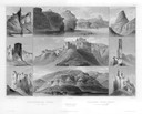
| Date: | 1832 |
|---|---|
| Description: | Remarkable Hills on the Upper Missouri River (views 10-29). Various scenes of land formations. |
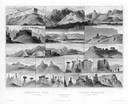
| Date: | 1832 |
|---|---|
| Description: | Remarkable hills on the Upper Missouri River (views 1-9). Various landscapes and rock formations. |
If you didn't find the material you searched for, our Library Reference Staff can help.
Call our reference desk at 608-264-6535 or email us at: