 Filter: Categories of Wisconsin Historical Images
Filter: Subject of Land
Filter: Year of 2000-Present
Filter: Subject of transportation
Filter: Categories of Wisconsin Historical Images
Filter: Subject of Land
Filter: Year of 2000-Present
Filter: Subject of transportation
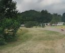
| Date: | 2001 |
|---|---|
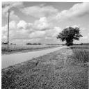
| Description: | Landscape view from the country road north of the Quinney farm. |
| Date: | 2004 |
|---|---|
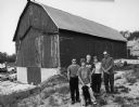
| Description: | The 6th generation of Keups now live on this farm. The property was purchased by David Keup in 1867. It was passed on to Martin, Herman, William, and now G... |
| Date: | 2004 |
|---|---|
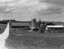
| Description: | This barn is at W487 Zion Church Rd (Section 26). Allen and Mary Beth Eilbes and sons Michael, Andrew and Mathew (by age) live here. |

| Date: | 2004 |
|---|---|
| Description: | About 40 elk are currently being raised on the Enderle farm by Tim Enderle. |
| Date: | 2010 |
|---|---|
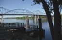
| Description: | View of two bridges, a pier, and trees along the Mississippi River. |

| Date: | 2013 |
|---|---|
| Description: | Map is the most extensive endeavor to date to accurately locate and document both prehistoric place names and natural features of the Menominee language wi... |
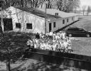
| Date: | 05 2000 |
|---|---|
| Description: | Group of students at Theresa Fireman's Park for Arbor Day activities. |
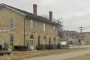
| Date: | 02 23 2012 |
|---|---|
| Description: | Exterior view of the railroad depot building. |
| Date: | 04 25 2012 |
|---|---|
| Description: | A view of the approach to the Village of Blue Mounds from the cemetery. |

| Date: | 2003 |
|---|---|
| Description: | The front of map shows trails throughout the bottom half of Wisconsin and includes text on snowmobile rules and tourism contacts. The reverse shows trails ... |
| Date: | 06 23 2012 |
|---|---|
| Description: | A house built on the former site of Mill's Saloon, which was next to Loddis Mill. A little girl is riding a tricycle up the street. |
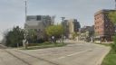
| Date: | 04 03 2012 |
|---|---|
| Description: | View down East Wilson Street across the railroad tracks towards condominiums and businesses on the 400 block, including the Cardinal Bar & Cafe at 418 East... |

| Date: | 2000 |
|---|---|
| Description: | This map shows national parks, county and state forests, Indian reservations, municipal land, private land, docks, boat access, camping, and points of inte... |
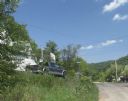
| Date: | 07 30 2012 |
|---|---|
| Description: | A view up a street, with a house and truck on the right. |
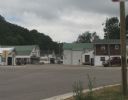
| Date: | 07 27 2012 |
|---|---|
| Description: | A view down Main Street in Beetown on an overcast day. |
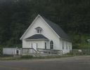
| Date: | 07 27 2012 |
|---|---|
| Description: | Exterior view of the Methodist Evangelical Church, with stairs and a ramp at the front of the building. |

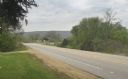
| Date: | 04 19 2012 |
|---|---|
| Description: | A view of the downtown area on a rainy day. The Woodford State Bank is on the left, and the street is lined with various storefronts and taverns. There is ... |

| Date: | 04 19 2012 |
|---|---|
| Description: | View towards the curve of Darlington Road when approaching Blanchardville. |
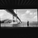
| Date: | 10 2013 |
|---|---|
| Description: | The movie "Vertigo" playing on a big screen in a darkened movie theater. The scene captured by the camera is of a woman walking along a the edge of the bay... |

| Date: | 11 2013 |
|---|---|
| Description: | Trees lining a dirt road covered in a light layer of snow in the Driftless Area. A rock outcropping is on the far left. |
If you didn't find the material you searched for, our Library Reference Staff can help.
Call our reference desk at 608-264-6535 or email us at: