 Filter: Categories of Wisconsin Historical Images
Filter: Subject of Land
Filter: Year of 1900-1999
Filter: Community of Madison
Filter: Categories of Wisconsin Historical Images
Filter: Subject of Land
Filter: Year of 1900-1999
Filter: Community of Madison
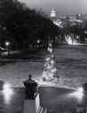
| Date: | 1960 |
|---|---|
| Description: | Elevated view looking east from Lincoln Terrace on Bascom Hill on the University of Wisconsin-Madison campus. The Lincoln Monument is in the foreground and... |

| Date: | 1952 |
|---|---|
| Description: | Aerial view of a North Central Airlines DC-3 airplane flying over the Madison isthmus. Clearly visible are the Wisconsin State Capitol, the 1 West Wilson S... |
| Date: | 1906 |
|---|---|
| Description: | Elevated view of Camp Randall Field from the top of Bascom Hall, with University Heights in the background. A crowd is in the stands at the stadium, and a ... |

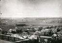
| Date: | 1940 |
|---|---|
| Description: | Aerial view looking east over the center of the city and the University of Wisconsin-Madison campus. |
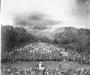
| Date: | 1916 |
|---|---|
| Description: | Maypole dancers at the University of Wisconsin-Madison on Bascom Hill (Main Hill). In the foreground is the Lincoln Monument. In the distance is the Wiscon... |

| Date: | 1908 |
|---|---|
| Description: | Colored map showing a panoramic view of Madison in great detail. The Wisconsin State Capitol is located at the center, with Lake Mendota in the background ... |

| Date: | 08 28 1970 |
|---|---|
| Description: | An aerial view of West Towne Shopping Center (now West Towne Mall) at Mineral Point and Gammon Roads. |
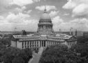
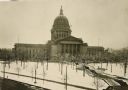
| Date: | 1945 |
|---|---|
| Description: | Elevated view of the Wisconsin State Capitol. The Belmont Hotel is behind the capitol on the left, and beyond is Lake Mendota. |
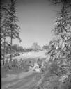
| Date: | 03 27 1928 |
|---|---|
| Description: | Winter scene with Agriculture Hall, covered with snow, on the University of Wisconsin-Madison campus. Agriculture Hall is in the distance. |

| Date: | 1908 |
|---|---|
| Description: | A panoramic aerial view of the Isthmus taken from a kite. Lake Mendota is to the right in the background with Picnic Point jutting into the lake. The photo... |

| Date: | 06 07 1954 |
|---|---|
| Description: | Aerial view of the Midvale neighborhood under construction showing the intersection of Midvale and Tokay Boulevards near the southwestern city limits of Ma... |
| Date: | 1930 |
|---|---|
| Description: | Elevated view of the west wing of the Wisconsin State Capitol building. A view of the fourth capitol with snow flocked trees and snow-covered lawn and side... |
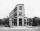
| Date: | 05 20 1930 |
|---|---|
| Description: | The Montgomery Ward Store Building at 100 North Hamilton Street, at the intersection of Pinckney and North Hamilton Streets. The building was designed by L... |
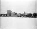
| Date: | 12 18 1955 |
|---|---|
| Description: | Downtown Madison lakeshore taken from Lake Monona in line with South Pinckney Street. Includes St. Raphael's steeple, 1 West Wilson Street state office bui... |

| Date: | 05 09 1908 |
|---|---|
| Description: | Kite aerial panoramic photograph of the central business district. In the distance is Lake Mendota. The fire damaged Wisconsin State Capitol is in the cent... |
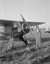
| Date: | 08 12 1932 |
|---|---|
| Description: | RKO motion picture actress Raquel Torres christening the new model airplane manufactured in Madison by Orland Corben. Corben had flown the airplane that br... |

| Date: | 10 30 1915 |
|---|---|
| Description: | Eighty-five Nakoma lot buyers enjoy a picnic in Nakoma, an outlying residential district. A quote on the print reads, "Go westward and grow up with Nakoma"... |

| Date: | 1904 |
|---|---|
| Description: | Monona Bay from the railroad trestle looking southwest, close to where the railroad tracks cross North Shore Drive, (now Brittingham Park), with old houses... |
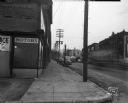
| Date: | 01 08 1946 |
|---|---|
| Description: | View down sidewalk along East Wilson Street at the corner of the South Hancock intersection looking toward the West Wilson Street-King Street intersection.... |
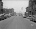
| Date: | 01 08 1946 |
|---|---|
| Description: | East Wilson Street scene looking northeast, taken at site of Reynolds Bus accident. Businesses shown include R & R Cafe at 316 East Wilson Street, Dizon Me... |
If you didn't find the material you searched for, our Library Reference Staff can help.
Call our reference desk at 608-264-6535 or email us at: