Filter: Categories of Wisconsin Historical Images
Filter: Subject of Land
Filter: Year of 1800-1899
Filter: Categories of Wisconsin Historical Images
Filter: Subject of Land
Filter: Year of 1800-1899

| Date: | 02 21 1874 |
|---|---|
| Description: | African American boatmen run a rapids in a small river boat. |
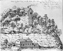
| Date: | 1853 |
|---|---|
| Description: | Engraved view of miners and hillside mines in the Lead Region. Caption reads: "Sketch of the Lead Region." |
| Date: | 1850 |
|---|---|
| Description: | Blast furnace, also known as a Scotch hearth used in lead mining. |
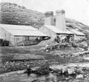
| Date: | 1884 |
|---|---|
| Description: | Native Americans playing a lacrosse-like game of ball. |

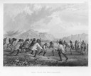
| Date: | 1890 |
|---|---|
| Description: | Highland Mines owner, Harris Lewis, center, with miners, stands before zinc ore crushers. |

| Date: | 1876 |
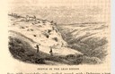
|---|---|
| Description: | Bird's-eye view of Black Earth. |
| Date: | 1884 |
|---|---|
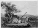
| Description: | Indians standing and sitting near wigwams. Four wigwam frames are covered, with the one on the right uncovered, with a campfire inside. In the distance are... |

| Date: | 1867 |
|---|---|
| Description: | Birds-eye drawing of Appleton, Outagamie Co., depicting street names and street layout, houses, the Fox River, the court house, jail, school houses, Lawren... |
| Date: | 1895 |
|---|---|
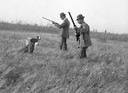
| Description: | Two hunters check their shotguns while their hunting dogs wait in the field. |

| Date: | 1839 |
|---|---|
| Description: | A map of the Wiskonsin [sic] and Neenah or Fox Rivers. |
| Date: | 1863 |
|---|---|
| Description: | Union army officers. From left are: General U.S. Grant, General Rawlins, General Webster, Colonel Lagow, and Colonel Killyer take a break. |

| Date: | 1870 |
|---|---|
| Description: | Baraboo was first settled around 1838, and by 1870 it had become the county seat and the thriving village illustrated here. This birds eye drawing depicts ... |

| Date: | 1897 |
|---|---|
| Description: | A view from the capitol looking west up State Street toward the University of Wisconsin-Madison with the Holy Redeemer Church, Holy Redeemer School, Red Gy... |

| Date: | 1879 |
|---|---|
| Description: | Bird's-eye view of Wisconsin State University, now the University of Wisconsin-Madison. Vignettes include Ladies Hall, South Dormitory, University Hall, As... |

| Date: | 1869 |
|---|---|
| Description: | Birds-eye drawing of Boscobel, Grant County, depicts street names and street layouts, houses, rivers and trees. A reference key at the bottom of the map sh... |

| Date: | 1886 |
|---|---|
| Description: | Bird's-eye map of Chippewa Falls, county seat of Chippewa Falls. |

| Date: | 1868 |
|---|---|
| Description: | This 1868 birds-eye view depicts the buildings, streets, railroad, vegetation and topography of Columbus, Wisconsin. The high school, cemetery, railroad de... |

| Date: | 1884 |
|---|---|
| Description: | Bird's-eye map of Delavan with inset of the State Institute for Deaf and Dumb. |

| Date: | 1867 |
|---|---|
| Description: | Birds eye drawing of Fond du Lac depicts street names and street layouts, houses, buildings, trees, and the Fond du Lac River. A reference key at the botto... |
If you didn't find the material you searched for, our Library Reference Staff can help.
Call our reference desk at 608-264-6535 or email us at: