Filter: Categories of Wisconsin Historical Images
Filter: Subject of Land
Filter: Year of 1800-1899
Filter: County of Brown
Filter: Categories of Wisconsin Historical Images
Filter: Subject of Land
Filter: Year of 1800-1899
Filter: County of Brown

| Date: | 1867 |
|---|---|
| Description: | Bird's-eye map of Green Bay and Fort Howard, Brown Co., depicts street names and street layouts, houses, trees, and the East River. A reference key at the ... |
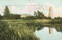
| Date: | 1898 |
|---|---|
| Description: | Caption reads: "Old Stone Tower and House, Long Tail Point, Green Bay, Wis." Water and a marshy area are in the foreground. |

| Date: | 1821 |
|---|---|
| Description: | Plan of the settlement of Green Bay. |

| Date: | 1835 |
|---|---|
| Description: | Ink on tracing paper map of Green Bay, Wisconsin and nearby areas, Lake Winnebago, Fox and Wolf Rivers, and the junctions of the Mississippi and Wisconsin ... |
| Date: | 1856 |
|---|---|
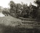
| Description: | ". . . At De Pere they stopped on the west shore for a broad sketch of the dwellings clustered on both sides of the river. The distant dam, the mills, ware... |
| Date: | 1873 |
|---|---|
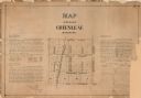
| Description: | A plat of the village of Greenleaf, Brown County, Wisconsin, showing the areas from Taintor Street to Day Street and Follett Street to Deuster Street. Inc... |

| Date: | 1890 |
|---|---|
| Description: | These hand-colored maps show the sections, lakes, swamps, streams, and state, vacant, entered, and withdrawn lands in ten survey townships in Oneida, Vilas... |

| Date: | 1836 |
|---|---|
| Description: | This manuscript shows the 1835 survey of the road corresponding approximately to a portion of County Trunk A in the Town of Scott, Brown County, Wisconsin.... |

| Date: | 1870 |
|---|---|
| Description: | This 1870 map of Brown County, Wisconsin, shows the township and range grid, towns, sections, cities, villages and post offices, land ownership, roads, rai... |

| Date: | 1896 |
|---|---|
| Description: | This map of Brown County, Wisconsin, from the late 19th century shows land claims along the Fox River, the township and range grid, towns, sections, cities... |

| Date: | 1868 |
|---|---|
| Description: | Map showing the northern water routes between Mississippi River and Atlantic Ocean Relief shown by hachures. Includes Profile of the Erie Canal, table of ... |

| Date: | 1893 |
|---|---|
| Description: | Bird’s-eye view of Depere looking North. Includes illustrations and an index to points of interest. |

| Date: | 1830 |
|---|---|
| Description: | Plat map showing lots and streets. A few lots are marked with names, including: Boyd, Newton, Williams, Baird, Suydam, etc. |

| Date: | 08 27 1825 |
|---|---|
| Description: | Map is ink on paper. Map shows plat of the town of Munnomunne, the Fox River, farm lots, and an established highway. The map is signed by "J.D. Doty, Propr... |

| Date: | 1875 |
|---|---|
| Description: | Elevated view over De Pere. In the foreground is the De Pere News Office and Post Office building. Behind it people are walking on the bridge over the Fox ... |

| Date: | 1836 |
|---|---|
| Description: | This map of Navarino shows a development plat of the village situated opposite Fort Howard at mouth of the Fox River. The names of proprietors are listed a... |

| Date: | 09 20 1836 |
|---|---|
| Description: | This map is ink and watercolor on paper and is an unnamed plat. Green Bay is labeled and the plat is labeled "Section 22." One road is labeled "Road to Nav... |

| Date: | 1844 |
|---|---|
| Description: | This map of Township number 24 North, Range 21 East is pen and ink on paper. The map also shows part of Township Number 23 North, Range Number 21 East. The... |
If you didn't find the material you searched for, our Library Reference Staff can help.
Call our reference desk at 608-264-6535 or email us at: