 Filter: Categories of Wisconsin Historical Images
Filter: Subject of Land
Filter: Subject of water
Filter: Categories of Wisconsin Historical Images
Filter: Subject of Land
Filter: Subject of water

| Date: | 1850 |
|---|---|
| Description: | Pastoral scene depicting a small bay on the Island of St. Ignace in Lake Superior with canoes on the rocky beach, two men conversing on a blanket in the fo... |

| Date: | 1850 |
|---|---|
| Description: | Pic Island on the north shore of Lake Superior. |

| Date: | 1851 |
|---|---|
| Description: | Plat map of the Town of Madison (Township 7N, Range 9E), from Volume 4, Federal Survey Plat Books. |
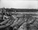
| Date: | 1903 |
|---|---|
| Description: | Three barefoot boys stand on a pile of logs in the foreground looking across the river at a group of men working to free a log jam in the Big Eddy on the C... |

| Date: | 1873 |
|---|---|
| Description: | Map of the township of Windsor, from the "Atlas of Dane County." |

| Date: | 1848 |
|---|---|
| Description: | In 1849, northern Wisconsin was composed of huge sectional regions such as Chippewa, Portage, Brown and Crawford, whereas southern Wisconsin was constitute... |
| Date: | 05 15 1954 |
|---|---|
| Description: | Zookeepers releasing rhesus monkeys to the island that serves as their summer home at the Washington park zoo (later replaced by the Milwaukee County Zoo). |

| Date: | 1697 |
|---|---|
| Description: | Father Hennepin's map in French of the upper lakes. |

| Date: | 1852 |
|---|---|
| Description: | Illustration of the Ojibwa, the Sacs, and Foxes battling from canoes on the water. |
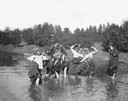
| Date: | |
|---|---|
| Description: | Group of women in comical poses pulling up their skirts while standing in a stream. One woman stands on the river bank on the right. Behind them is a hill... |
| Date: | 1840 |
|---|---|
| Description: | Photograph of a painting of the second Fort Crawford, built 1829-1835. Two men are in a boat in the water in the foreground. The first Fort Crawford at Pra... |

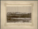
| Date: | 1856 |
|---|---|
| Description: | View looking west from Lake Michigan with several steam ships and sailing vessels in harbor. There is a lighthouse to left of center, along shoreline. |
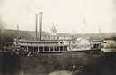
| Date: | |
|---|---|
| Description: | The sidewheel packet, Belle of La Crosse, at a landing on the Upper Mississippi River. The sidewheel was built in 1868 and burned while in winter qu... |
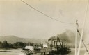
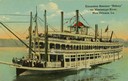
| Date: | 1899 |
|---|---|
| Description: | The Clyde after being converted to a sternwheel rafter, pushing a tow with a locomotive on board. |
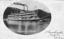
| Date: | 1907 |
|---|---|
| Description: | The sternwheel excursion, J.S., underway taken between 1901 and 1907. Oval picture inscribed Burlington, July 10, 1907. |
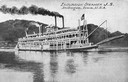
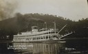
| Date: | 1901 |
|---|---|
| Description: | The sternwheel excursion, J.S. in the middle of the Mississippi River. The opposite shoreline is in the background. |
| Date: | |
|---|---|
| Description: | The sternwheel excursion, Sidney, leaving Lansing, Iowa. Later named Washington. A crane on the front of the steamer is attached to a passeng... |
| Date: | |
|---|---|
| Description: | The sternwheel excursion, Sidney, on the Mississippi River at New Orleans. All three decks are full of passengers. Later named "Washington." |
If you didn't find the material you searched for, our Library Reference Staff can help.
Call our reference desk at 608-264-6535 or email us at:

