 Filter: Categories of Wisconsin Historical Images
Filter: Subject of Land
Filter: Subject of veterans
Filter: Categories of Wisconsin Historical Images
Filter: Subject of Land
Filter: Subject of veterans
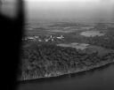
| Date: | 10 10 1947 |
|---|---|
| Description: | Aerial view of the Wisconsin Memorial Hospital run by the Veterans Administration on the north shore of Lake Mendota on the grounds of the Mendota State Ho... |
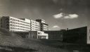
| Date: | 1951 |
|---|---|
| Description: | The Veterans' Administration Hospital, located at 2500 Overlook Terrace. |
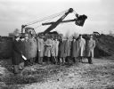
| Date: | 11 23 1948 |
|---|---|
| Description: | This ceremony at Truax Field signaled the start of construction of the 120-unit apartment project for war veterans by the Madison Housing Authority. Henry ... |
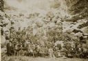
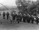
| Date: | 09 16 1896 |
|---|---|
| Description: | Outdoor group portrait of a reunion of the Iron Brigade, veterans of the Civil War, and their families at Devil's Lake, Wisconsin. The couple seated in... |
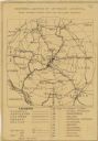
| Date: | 1920 |
|---|---|
| Description: | This map produced just after Word War I shows the proposed location for a veterans' hospital in the Eau Claire-Chippewa Falls region. Highways, rail lines ... |
| Date: | 05 1983 |
|---|---|
| Description: | "Theresa American Legion members paid homage to former comrades on Memorial Day at the River Church Cemetery." |

| Date: | 06 15 1953 |
|---|---|
| Description: | View across road towards eight members of Madison American Legion and its Auxiliary posed and raising a large new flag at the Veteran's Administration Hosp... |

| Date: | 1792 |
|---|---|
| Description: | Map of the United States east of the Mississippi River and north of the Ohio River. It shows the borders between the north eastern states, Canada and the U... |

| Date: | 1795 |
|---|---|
| Description: | Detailed map of Kentucky and most of Tennessee. The map shows the borders, counties, cities, towns, Native American towns, forts, roads, mountains, lakes, ... |
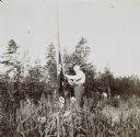
| Date: | 1898 |
|---|---|
| Description: | I.P. Rumsey is raising the Island Lodge flag. Caption reads: "Up with the flag! I.P. Rumsey." |
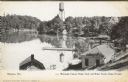
| Date: | 1907 |
|---|---|
| Description: | Text on front reads: "Waupaca, Wis. Wisconsin Veteran Home, Dock and Water Tower, Chain O'Lakes." Elevated view from hill of a man on a pier, walking towar... |
If you didn't find the material you searched for, our Library Reference Staff can help.
Call our reference desk at 608-264-6535 or email us at: