 Filter: Categories of Wisconsin Historical Images
Filter: Subject of Land
Filter: Subject of united states. army
Filter: Categories of Wisconsin Historical Images
Filter: Subject of Land
Filter: Subject of united states. army

| Date: | 1931 |
|---|---|
| Description: | A topographical map from the U.S. Army Corp of Engineers showing the topography and man-made features in the Camp Williams area of the towns of Orange and ... |

| Date: | 1960 |
|---|---|
| Description: | This map is a facsimile of a 1829 map and shows private land claims, landowners within military reserve boundaries, sawmill, Fort Howard, public barns, bri... |

| Date: | 04 11 1940 |
|---|---|
| Description: | This blue line print map shows survey monument markers by type and industrial buildings and covers part of the lower Fox River and East River. The map incl... |

| Date: | 07 22 1929 |
|---|---|
| Description: | Three-quarter view from front left of a Thaden T-2 parked outdoors. Manufactured by the Thaden Metal Aircraft Company of San Francisco, California. The com... |
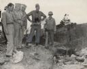
| Date: | 09 19 1944 |
|---|---|
| Description: | Five men in uniform stand over a partially obscured body on a hillside. Another soldier is behind the group on the left. Caption reads: "Fifth Army, Bonzal... |
If you didn't find the material you searched for, our Library Reference Staff can help.
Call our reference desk at 608-264-6535 or email us at: